Lake District, June 2022: 6 – Climbing Napes Needle

Thursday 16 June

Our appetite for climbing had been whetted by the previous day’s excursion in the Eskdale Valley and the weather looked dry, so after breakfast and red squirrel watching at the campsite Ryan and I left the others for an attempt at a particularly special rock climbing route. Mum, dad and Angus would spend the day catching the train from Dalegarth, the cute station we’d walked to a couple of evenings before, to explore Ravenglass on the coast. Angus thought about coming with us but decided that he was happy to have hiked up Helvellyn and climbed already at Hare Crags, so he decided to commit some time to steam trains, historical places and other Angus-like stuff.

Napes Needle

Napes Needle is one of the UK’s most iconic climbing destinations. Set halfway up the south face of Great Gable at the end of dramatic Wasdale valley, the popular starting point for Scafell Pike, it is a distinctive, upright pinnacle of igneous rock about 18m high at an elevation of 680m. Ryan’s dad had been to see it in his mountaineering days and it was detailed in all of his old climbing books, so we felt obliged to go and stand on top of it – for me, classic routes of such rich historical calibre have a special kind of allure.

We bought lunch from a tiny shop in Eskdale village and drove along little roads to Wasdale. As we reached the banks of the wild, black Wast Water, the deepest of England’s lakes, we seemed to shrink into a landscape that grew upwards all around us all the way to Wasdale Head, the dead-end hamlet nestled in the heart of the long, three-sided valley. Each mountain merged into the next in a vast mass of green and grey, and I felt that spine-tingling anticipation that I only ever seem to encounter in wild, whispering places that seem as old as time.

Approach

The weather was cloudy but clear, and Great Gable – along with its nearly-as-gargantuan sister Kirk Fell – blocked the head of the valley like a sleeping guard dog. Named for its recognisable pyramidal outline when seen from Wasdale, its southern aspect has a distinctly serious look about it: loose, grey scree sweeps down into the valley, dominating over scrubby grass that grows patchily wherever it can take hold, for about three quarters of the way up its steep face until turning to huge, vertical blocks of grey rock that form cracked, triangular ridges all the way to the 899m summit. Although the walk-in is barely two miles as the crow flies, it involves hiking up about 650m of steep elevation gain on awkward terrain, as we would soon discover.

The first mile took us through a farm and along Lingmell Beck, a suspiciously flat, pleasant walk between the hulking sides of Lingmell and Wasdale Fell. Ryan decided that he felt unwell after crossing a little bridge just before the ascent began, so we sat down and he ate a pasty while I masked my concern that he might get ill on the mountain. He perked up a little and we began the climb up to the climb. It was an unforgivingly steep and direct route up a rocky, grassy path, and I kept an eye on Ryan while making a concerted effort not to go too far ahead. Luckily he seemed to recover just as the going got really tough, when we calculated (using an OS map) that it was time to turn off the path and seek the Needle high up on a steep scree slope spanning the face of the mountain.

There was no obvious path that branched off, so we found ourselves scrabbling sideways across tight clumps of grass and loose, slippery scree on the most-path like course, which wasn’t path-like at all. This continued for what felt like an age, and was really quite treacherous – most of the scree chunks qualified as small boulders, which we desperately didn’t want to send toppling down the side of the mountain, and neither did we want to go that way. As well as unstable the ground was very uneven, with boulders of all shapes, sizes and jaunty angles jabbing into legs and doing their best to roll ankles. We also had to keep our eyes peeled to the left, as Napes Needle was marked on the map (such is its significance) along the ridge of sheer grey, samey-looking cliffs and ridges that we’d seen from the car park.

The Needle

After a couple of false identifications, a lot of staring at seemingly identical pinnacles of grey rock and even more frustration at the ongoing struggle over tricky ground, we suddenly looked straight up at the unmistakeable Napes Needle. We approached up a deep, rocky, grassy gulley and, on seeing a couple of climbers already on it, scrambled up the rocks opposite and perched on a grassy ledge overlooking the Needle and its mind-blowing backdrop.

Seeing Napes Needle in person made me appreciate why it has its own name, position on the map and place in mountaineering history. Its undeniably phallic form stands independent from the rocky ridge behind it, a proud pinnacle watching over the valley beneath Great Gable. A skyward-pointing arrowhead forms its right hand side, split neatly into large triangles and diamonds by large, geometric cracks. The wildly undulating slopes of Lingmell rose up across the other side of the valley, looming over grassy Wasdale to the right, and just behind the Needle the immense form of Scafell Pike sat neatly between the rugged shoulders of Lingmell and Great End. To our left hulked the intimidating southern face of the top of Great Gable, a vertical maze of sheer ridges, slabs and gulleys, the blocky, brown-grey rock punctuated by grass wherever it could set root. There aren’t many climbs I’d queue for, but this is one of them.

One pair of climbers was on the second of the two pitches and another pair was gearing up ready to climb, so we sat across the gulley and watched. It was mild, sunny, still and clear, perfect conditions, and we happily ate snacks and photographed the other groups. Another pair scrambled up and onto Needle Ridge, the long route we’d complete in a few days time (and a later blog post) that began in the V between the Needle and the exciting-looking ridge behind it, so they were added to my “give me your email address and I’ll send you the photos” list, which I made by calling across the gulley.

The first pair abseiled off, which was helpful to see as we’d read mixed reviews of the abseil online, and later confirmed that the in-situ gear is good. We had to wait a while for the second pair to climb but we didn’t mind – we took photos and encouraged them from across the gulley. When they started abseiling down we crossed to the base of the Needle, geared up and discussed who would lead each of the two pitches of the classic 18m HS climb “Wasdale Crack”.

The first pitch was a 13m diagonal climb up the large crack between the arrowhead and the needle to the “shoulder”, a ledge just below the bulbous tip of the needle. The second was a short 5m up the back of the tip, but is famously polished and supposedly the crux move. We decided that I should lead the longer, crackier pitch due to Ryan’s injured toe (see previous post for an explanation) and he would do the short move to the top, so I chose some nuts and cams and started up the crack.

It was a straightforward, easy crack climb and the gear was solid, but its polished surfaces worn shiny by thousands of climbing shoes added a layer of uncertainty and excitement. I reached the belay without much difficulty, clipped into the five in-situ slings thrown around an overhang under the back of the rock, added a couple of nuts for extra protection and brought Ryan up from a very comfortable anchor. He tiptoed around the bulbous, exposed end of the “needle” and after some minor reluctance, pulled himself up and over the summit. He made an anchor by draping the rope under the overhanging rock and brought me up, at which point I understood his hesitation – the holds were polished, the moves were awkward and the position was extremely exposed.

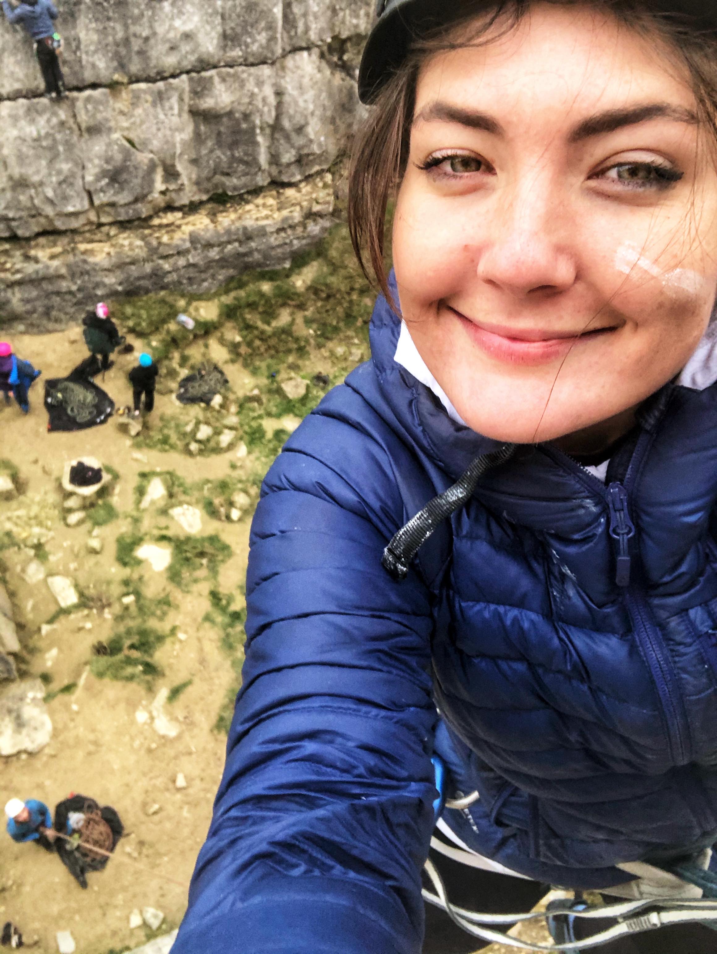
Standing on top of that pinnacle was a surreal experience. We were on a tiny island just big enough for two people to squeeze onto, surrounded by a sheer 15-20m drop on all sides. The dramatic panorama I’ve already described stretched around us, the valleys seemingly even deeper, the mountains even wilder and the horizons even further than they had been before. It was isolated, extremely exposed and somehow serene.

After a long, quiet moment of appreciation, I downclimbed to my belay point and Ryan followed my instructions, boldly downclimbing while removing the gear he’d placed. He nearly failed to dislodge a nut, later joking that he could have been “that guy that placed the big silver nut in Napes Needle”, but managed to get it back and return safely to the ledge. We clipped into the five slings, noting that at least two looked new, and took it in turns to abseil down the first pitch. Back on the ground, we packed up our stuff, vowed to come back to do Needle Ridge, and scrabbled out of the gulley and away from the Needle.

Descent

We headed east along more treacherous scree for about a kilometre, following an extremely vague path through the rocky rubble. At one point I kicked a rock (thankfully I had my stiff approach shoes on so no further toes were injured), stumbled and nearly toppled sideways down the steep slope – I caught myself just in time and when I turned around, saw that Ryan had also grabbed my rucksack. By the time we reached the main path through Lingmell we were quite bored of the awkward ground, where every step necessitated precise planning and execution, and it was nice to be back in amongst the ferns.

We walked back to the car along the base of Great Gable’s intimidating southern face, surrounded by high, unforgiving fells and pleased with the day’s adventure. Back in the idyllic agriculture sliver that is Wasdale Head, a tiny green paradise wedged between the monstrous hills, we nosed around the miniscule St Olaf’s Church, but later returned with mum, dad and Angus so I’ll save writing about it until then. It had just gone 6pm and we were due to meet the others at the Woolpack Inn in Eskdale for dinner, so we shot back to the campsite, changed and walked the short distance along the road to the pub.

The Woolpack Inn

The Woolpack is a historic inn nestled deep in the Eskdale Valley, miles from any major town, let alone phone signal, yet somehow it always seems to have a nice, quiet buzz – I’d visited years before and we’d been in for a drink the previous day. Painted white with black-framed windows, high-ceilinged and timeless, it feels very welcoming after a day in the mountains. We sat out the front in the large, grassy garden and Angus and I argued for a while about something or other until it turned too political and dad issued a telling off – at least it had taken us until Thursday. I had a lovely stonebaked veggie pizza from the simple but varied menu and the others had various forms of pizza, pie and salad, then we walked back along the quiet, bucolic road and had Ovaltine in the awning. A relaxing end to an eventful day.

Scotland, Feb ’22: Steall Falls, indoor climbing at Kinlochleven

Saturday 12 February

The weather was not on our side, so we planned some rest day activities. We left our little Fort William hotel room at 10am and drove southeast for 20 minutes to the car park for Steall waterfall and wire bridge, which we’d found in the Wild Guide. The drive took us on a winding road through high-sided, picturesque Glen Nevis, with Ben Nevis towering over our left side and the thickly forested slopes of lower, but no less wild, peaks on our right. We arrived at the small, dead-end car park and set off along the well-walked, rocky path for the waterfall.

An Steall waterfall walk

The path ran above and parallel to the Water of Nevis, which flowed fast and relentless along its rocky course. Little waterfalls fed it from all around, some flowing under wooden bridges built into the path. Our 150-200m elevation gave wonderful views over the rushing white river and the deep, dramatic glen, whose high, undulating sides were a colourful patchwork of yellow grass, green pines, lilac-pink birches and orange heather under a thick grey sky, which absorbed the snowy upper reaches of the steep slopes and made the valley feel very self-contained. The path ran for a mile through leafless trees connected by lush green mosses, then curved with the river and dropped down to just above river level, where the valley floor widened slightly into a grassy plain set in a long, steep-sided basin.

We turned a corner and An Steall waterfall, the third highest in Scotland, burst from the huge, craggy valley side ahead of us, a 30 foot high, furious deluge of charging white horses. A few minor falls sat thinly either side of it like veins, but An Steall was the queen of the valley, the magnificent, roaring centrepiece. She fed the Water of Nevis with an endless torrent, giving it the energy to push its way over the rocks and around the twists of Glen Nevis.

Steall wire bridge

Steall wire bridge was on our right just before the waterfall, suspended 10 feet over the river. We waited for a couple of others to cross, then approached the pebble river bank. The bridge consists of three thick steel cables about 20 feet long, two for hands and one for feet, held across the water by a sturdy metal frame at each end. We took turns to walk out over the bridge and back, placing our feet very carefully on the wobbly metal tightrope. It was more nerve-wracking than I expected as the wires move quite a lot and there is nothing below other than a substantial fall, the rushing white river and a lot of cold, hard, wet, uncomfortable-looking rocks, but that meant it was also a lot more fun than I expected.

More people turned up so we left the bridge and retraced our steps back to the van, through that almost lower Himalayan valley. We left Glen Nevis and went back to Fort William for fuel and snacks. At the petrol station the clouds unleashed a sudden deluge of rain, possibly the most savage I’ve ever seen, and we had to wait a few moments for it to ease as it was heavy enough to obliterate all visibility. Once we could see again (only just), we decided to head towards Glencoe via Kinlochleven to climb at Ice Factor, the National Ice Climbing centre. The ice wall was fully booked but we were quite happy to squeeze some indoor rock climbing into the trip and avoid the weather.

Ice Factor, Kinlochleven

The journey south along the bank of Loch Linnhe, then east along Loch Leven, took about 40 minutes, and although the clag obscured the mountains it was nice to get a good view of the lochs. Ice Factor is oddly situated in the quirky, remote village of Kinlochleven, nestled cosily at the head of Loch Leven and closely surrounded by mountains, in a high-ceilinged, old stone aluminium works building. It’s a buzzing, modern, warm place with an indoor ice wall, climbing and bouldering wall, outdoorsey shop, cosy café and soft play area.

The climbing area wasn’t huge but it was plenty big enough, and we led (up to 6b, notably on which I slipped off above a bolt and took a pleasant little fall), toproped and autobelayed some interesting routes. The natural, rock type feature walls were particularly fun as they enabled us to practise crack climbing, which is difficult to replicate with bolt-on holds. We stayed a good couple of hours, had a coffee in the café, snuck into the small bouldering room and left before we lingered long enough in the shop to buy something unnecessary.

Glencoe

We drove west along the south bank of Loch Leven and into Glencoe, my favourite place. Sandwiched between the distinctive, imposing Three Sisters to the south and the hulking ridge of Aonach Eagach to the north, the Pass of Glencoe snakes through the dramatic valley next to the rocky River Coe. Yellowish grass grows up the lower swathes of the mountains either side but the higher reaches deny it access, their harsh, dark faces being too steep and inhospitable for anything but bare rock and snow. As usual in that vast, wild place, I felt incredibly small.

We continued east, took a turn onto the small road to Glen Etive and parked in a quiet pull-in by a wooded stream below the impossibly triangular east face of Buachaille Etive Mor, whose four colossal summits we planned to take on the following day. Ryan cooked vegan burgers for tea (delicious) and we did some planning then had an early night, buzzing for the hike.

Snowdonia, Sep ’21: Climbing at Dinorwic Quarry

Tuesday 21st September

Following the previous day’s scramble around the Snowdon Horseshoe, we treated ourselves to a lie in and a cooked breakfast in the van before a day of easy-ish sport climbing at Dinorwic Quarry, near Llanberis. We left the Tyn y Coed pub car park in no particular rush and drove along the scenic road that took us past Capel Curig, through the Dyffryn Mymbyr Valley and down the wild, rugged Llanberis Pass. At Llanberis we followed the road along the west side of Llyn Peris and Llyn Padarn, whose murky waters rippled beneath the  strikingly grey walls of the huge slate quarries behind them.

We turned right at the end of Llyn Padarn and found ourselves coming back along the other side of the lake on a narrow, bumpy road. After a couple of miles we came to the roadside parking described in our climbing guide.  We were trying to fathom how to get to “The Sidings” area of the “Australia” sport crag when a very friendly man who’d just parked behind us saw our van and started talking to us about Mazda Bongos. It turned out that he and his friend (I think their names were Pete and Mike) had come to climb very near Australia, so they offered to show us where it was.

We’re very lucky to have bumped into them because as well as being a short walk from where we parked,  we’d have struggled to match up the pictures in the guide with the corresponding bits of crag. We were blown away by the scale of the huge, grey crater, whose hulking back towered high above a deep, wide bowl of greyer-than-grey slate vertical walls and what must have been millions of tons of rubble.  Occasional stone huts, miscellaneous bits of steel apparatus and rusty old cables hinted at the quarry’s history as a hive of activity and noise, but it seemed to have become quite a serene place in its abandonment.  Looking over to the Llanberis Valley, Llyn Padarn and Llyn Peris took on a kind of cloudy blue colour when viewed from above, and the rugged ridges of the Snowdon mountain range reached towards the sky under a gentle sun that reflected off the land in a blueish haze.

Our new friends pointed the way to The Sidings, which was a steep-ish hike up a long, scree-covered ramp. In places the towering quarry walls were divided into several stepped levels, separated by flat platforms which were perfect for belaying. We set up on the second or third level up the  north-western side of the quarry, about halfway between the bottom and the top of the crater. Looking over the slatey bowl I saw that tons of loose rock lingered on the nearly sheer slopes, waiting to be released as a hard, grey avalanche. Several huge vertical slabs refused to hold onto any scree and towered  over the bowl, looking appealing – if imposing – as multi-pitch trad climbing routes.

The Sidings is a platform about 80 metres long that runs below a near-vertical wall 10 metres high. As we were out of the habit of regular outdoor climbing due to lockdown, we chose this area due to the low grade of its 18 routes, which range from 4 to 6a+. I started off by leading “N Gauge” (6a), which was my first ever climb on slate.

I was pleasantly surprised how solid the rock felt. As expected of a slate wall, much of the surface was smooth and bare, but where small edges and cracks did appear they were angular, hard and “trustworthy” – if rock can bear such a characteristic – although I’d later revise this conclusion, as I’ll explain shortly. I enjoyed the mix of fingery, balancey moves, some of which were quite technical, and the lack of large ledges reassured us that we could fall without hitting anything.

We worked from left to right, ticking off N Gauge (6a), Side Line (4+), Derailed (4), Thomas the Tank (4), Not Known (6a), Rack and Pin (5+), Sodor (6a), Being a Bob (5a), “Those who climb clearly marked projects are the kind of people who would steal the chocolate bar from a kid’s lunch box – selfish tossers – who owe the bolt fund cash” (5+, well named) and Choo Choo (5+).

Not Known wasn’t marked in our guide book but  was clearly bolted and looked interesting, if tricky, so I led it with trepidation and was secretly very pleased with myself when I made it over the crux move, which involved a very high leg (which defied Ryan on his attempt), a good hip flexor stretch and a lucky high left hand hold. It probably helped that Pete and Mike had joined us at The Sidings, so I had the additional incentive of being watched. Pete suggested that the climb might be graded 7a, so I was quite disappointed to read on the UKClimbing website that it’s only 6a. Regardless, it was good to climb something blind to the grade.

Rack and Pin and Sodor felt quite exposed, but climbing next to a group of 3 or 4 beginners being coached by a guide – again, people to watch us – gave us a reason to ignore any nervousness. Having previously noted the “trustworthiness” of the rock, I was given a shock near the bottom of Rack and Pin when, having only clipped into the first bolt, a tiny handhold broke off suddenly under the pressure of three of my left fingers as I pulled down. I’d climbed above the bolt and was sent sprawling off the rock and swinging awkwardly to the right, but Ryan caught me quickly and I landed against the wall before I’d even processed what had happened. This reminded me that in general, falling isn’t so bad after all.

Once we were satisfied with our day’s climbing, we packed up and walked down into the belly of the quarry for a poke around. We entered through a deep archway cut into a huge slab and stared up at the impossible quantities of slate. Grass, heather and lichen softened the greyness, and we noticed several alluring black openings that suggested that there was plenty of exploring to be done behind the quarry walls.

We entered a ground-level shaft about 8 foot high and 6 foot wide, and walked the length of it up a gradual slope along an old railway track. It was about 100 metres long, damp and very dark, and near the end it forked into two openings. They both came out at the side of the quarry and dropped down steeply.  We decided that climbing aside, we could spend a day just exploring the quarry; Pete had told us about “Snakes and Ladders”, which is a popular excursion on rainy days that involves climbing – preferably with a rope – up rusty old ladders and shafts inside the quarry walls. In short Dinorwic quarry is an excellent, if perilous, playground.

We left the quarry and walked across to the viewpoint that overlooks Llyn Padarn, Llyn Peris and the bottom of the Llanberis Pass, over which the rugged Snowdon peaks provided a lovely backdrop in the afternoon sun. We marvelled at the amount of loose slate and joked that we could find ourselves a lovely set of tablemats and coasters for our new house – and all our friends’ and families’ houses – without making a dent, then wandered back to the van. We drove to the bus terminal at the end of the road to turn around and were amazed to spot Johnny Dawes, the eccentrically-dressed 50-something year old rock climber famous for his bold ascents and ability to climb hands-free, pulling a rope out of a nondescript car ready to take himself off for a climb. I’m embarrassed to say that we gawped like fangirls.

Keen to find somewhere for food and a drink, we drove back into Llanberis and found ourselves at a pub in the middle of town, “The Heights”, which was big and cheap and cheerful enough, if a little dated.  We sat on a bench outside and shared a large, very satisfying plate of nachos, then agreed to go back up Llanberis Pass to try the Vaynol Arms. On arrival I was quite disappointed to find that since I’d last been in a couple of years before, its lovely old tartan-patterned ceiling had been painted white and the fascinating old mountaineering paraphernalia that was hung above the cosy fireplace has been dissipated around the now much colder looking pub.

We considered eating in the pub but being mid-week, there wasn’t much of an atmosphere so we had a drink and left. We drove back up the Llanberis Pass, turned left and dipped into the wild Dyffryn Mymbyr valley. We parked in the overnight spot we’d stayed in on Sunday, I cooked a surprisingly tasty improvised dinner of bulgur wheat, tinned soup and whatever-else-I-could-find-in-the-cupboard stew, and we drifted into the blissful kind of sleep that can only be achieved in the wildest places.

Snowdonia, Sep 21: Climbing Little & Big Tryfan (Pinnacle Rib Route)

What a week. We’ve just returned from an incredible trip to Snowdonia and the mountain blues have hit us like a steam train. Hiking, scrambling, climbing, mountain biking, an island road trip, a smidgeon of wild swimming and several pubs – the last few days have had everything I could have asked for and more.

Friday 17th September

We drove up on Thursday night and stayed in a layby just before Betws y Coed. After a good night’s sleep and eggs on toast for brekkie, we drove west along the A5 through the picturesque valley that cuts through the lush, green Gwydir Forest. Past the trees, the landscape opened out to wild country, where mountains sprawl lazily for miles across rugged land untainted by concrete or tarmac.

Little Tryfan

After a 20 minute drive we parked in the long layby on the A5 just after Gwern Gof Uchaf campsite, nestled in the Ogwen Valley. We fancied a gentle introduction to what we (rightly) anticipated would be a full-on week, so we started with some easy trad climbing on Little Tryfan, where I’d climbed with army cadets a decade ago and Ryan had climbed a couple of years ago. We tramped past Gwern Gof Uchaf and a short distance up the south side of the valley to the huge, slanting rock face, whose gentle angle and solid, grippy rock make it the perfect destination for new or casual climbers.

Most of the wall was being used by a big army group so we walked past them to the far end and climbed “Mossy Slab”, an easy two-pitch route graded HVD. I led the first pitch and Ryan led the second. Some of the gear was good but I found that several of the crack constrictions were “wrong” in that they were V-shaped and didn’t allow nut placements to correspond with the direction of fall, but the climbing was so easy that I was comfortable with running the gear out. At the top we paused to appreciate the stunning view of the Ogwen Valley, then walked down the rightward descent scramble.

We felt that Little Tryfan was one of those “if you’ve climbed one route, you’ve climbed them all” crags, so at the bottom I put forward a case for climbing “big” Tryfan. My arguments were:

  1. the weather was drier and clearer than forecast,
  2. we were part way there anyway,
  3. we’d packed enough equipment to not have to return to the car, and
  4. we’d already discussed climbing it via a certain route called First Pinnacle Rib.

Ryan put up precisely no resistance and insisted that he’d be fine in his battered old Nike skate shoes. It was one of those off-the-cuff decisions that lead to the best days out, and the verdict was unanimous. Off we went.

Tryfan: to Heather Terrace

The first bit involved a steep walk/scramble up to Heather Terrace, the path that runs roughly north-south along Tryfan’s east face and is characterised by uneven rock, unavoidable grey boulders, resolute purple heather and lovely high views over the valley of Cwm Tryfan. Heather Terrace is probably the gentlest and flattest route up Tryfan, a mountain whose summit requires at least a scramble regardless of which way you go.

Once we were in roughly the right place along the path, we searched the rock for the start of the climbing route. We’d eyed up First Pinnacle Rib (also called Overlapping Ridge Route), a classic VDiff multi-pitch that featured in both our new Rockfax book and Kev’s (Ryan’s dad) 1990 Constable guide, which Kev had climbed years before. We couldn’t easily tell exactly where the routes were as the rock to our right was high, steep and looked very much the same, and the photos in the guidebooks were taken from further back – we’d have fallen off the side of the mountain if we stepped back to gain the same vantage point.

After a frustrating 20 minutes or so I spotted “FPR” vaguely etched into a slab. Kev had told us that “1PR” was scratched at the bottom of the route, so we assumed that the “1” had been turned into an “F” at some point and didn’t investigate further. A few days later we spotted in the Rockfax book that FPR actually and misleadingly denotes the start of Pinnacle Rib Route, fortunately another classic VDiff which is next to First Pinnacle Rib, so that’s what we set out on.

Tryfan: Pinnacle Rib Route, the nice bit

We shoed, harnessed, helmeted, geared and roped up and I led the first pitch, an easy line up a big groove with good gear and solid holds. Ryan followed me up and led the second pitch up a rib, again with good gear and holds. I came up and led the third; we weren’t exactly following Rockfax’s instructions as to where to climb/belay, but just doing what looked good and felt right. I paused a couple of times to snack on some wild bilberries that grow on scrubby bushes all over the mountain.

The first slightly sketchy section came at what I thought was “Yellow Slab”, an infamous polished wall. With hindsight and research I don’t think it was Yellow Slab, but I found myself on a flat, vertical face covered in thin yellowish lichen, few holds and fewer gear placements, just past a flat ledge and out of Ryan’s view. I felt strong and confident so I pulled myself up, managed to place a small blue nut which subsequently popped out shortly after I climbed above it, and belayed from just above it – fortunately it was quite short.

We were enjoying the climbing hugely and flying up quickly until Ryan finished the fourth pitch and belayed me up. The sky was starting to cloud over and at one point I was climbing above a rainbow, which was cool. However, Ryan had gone slightly off-piste by climbing in whichever direction he liked the look of, and we weren’t entirely sure where we were. We read something in the book about walking rightwards for 20m and belaying, so we tramped right up some awkward wet, heathery ground and stopped at a slightly ominous-looking corner crack.

Tryfan: Pinnacle Rib Route? The ordeal

For reasons that will become clear, I don’t have any photos of this section. The weather had closed in, the stunning views had gone, we were starting to get damp and Type 1 fun was rapidly turning into Type 2. Looking a little reluctantly at the wet corner, I started up it and quickly realised that opportunities to place gear were scarce. It followed a crack up a corner between two fairly bare slabs which tilted towards each other at a shallow angle, not enough to properly bridge, meaning that I had to trust my shoes to grip the damp rock on tiny or next-to-no holds while I made some awkward upper body moves. The crack itself was slimy and mossy and the gear placements just got worse.

I climbed quite slowly, constantly weighing up whether to carry on or come down. The gear became so run-out that if I slipped it’d have been a ground fall onto the ledge where Ryan was belaying (very supportively and encouragingly despite his soaking wet shoes, to his credit), a fact of which I was painfully conscious. When I was climbing my head was calm, clear and acutely aware of everything, but when I paused to look for a much-needed gear placement I felt genuine fear. I’m not used to that feeling – there’s a difference between the adrenaline-inducing thrill of climbing above a bolt at a crag, flying down a steep mountain bike trail or scrambling along an exposed ridge, or even worrying a little that we’d get back later than planned after a big day out, and real, spine-chilling, one-wrong-move-means-hello-mountain-rescue fear.

Eventually I reached a good handhold where I placed two nuts. I didn’t allow relief to wash through me because the next few metres looked as bare as the previous few. I convinced myself to carry on, then proceeded to put myself through the same torment as before, with a long, run-out, balancey few moves up slippery rock until eventually (another potential ground fall later) I reached a horn of rock, which I threw a sling over, clipped into and fully exhaled for the first time in a good few minutes. From there I clambered up onto another horn, which I straddled tightly and belayed Ryan up from, genuinely relieved to be unscathed.

Ryan followed me up and congratulated me on being alive and unbroken, then led the next pitch up an awkward channel which luckily had plenty of gear placements. I followed him, a bit shaky from my belaying position, and met him at his belay. I was a bit disheartened not to see Adam and Eve, the two adjacent pillars that mark the summit, but after a slightly awkward scramble up a column of rock they emerged through the clag to our immense relief.

Tryfan: summit, descent

Ryan clambered up first and did the famous leap between the pillars to gain the “freedom of Tryfan”. I followed, still a little shaken from that hellish pitch, and jumped across before I could ponder the sheer drop to the left, the wide gap between the rocks or the slippery-looking, uneven surfaces on the tops. Ryan thought it funny to tell me I had to do it again as he’d missed the photo; I did not find it funny. Fortunately (for him) he’d captured it perfectly.

We swapped climbing shoes for Scarpa approach shoes / Nike pumps (joking that Ryan was now “that person” we hate to see up mountains), munched a cheese salad sandwich and walked down the steep south side of the mountain until we branched left and rejoined Heather Terrace. The terrain was awkward, uneven and very rocky, and our knees took a battering all the way down. The clag lifted as we descended, the landscape-defining artery of Nant Gwern y Gof appeared way below us to the right, and eventually the views over the long Ogwen Valley returned.

The Perfect Ending: pub, curry, van

We passed behind Little Tryfan, through Gwen Gof Uchaf and returned to the van around 5.30pm, pleased to see the bikes hadn’t been stolen and slightly amused that we’d only travelled just over 4 miles (2,000ft elevation aside). We threw our stuff in and drove the short distance down the A5 back to Tyn-y-Coed, a nice, welcoming pub Ryan had frequented on a previous trip with his brother. I was revived by a cider and an Irish coffee, then Ryan drove us back along the A5 to a car park by Llyn Ogwen, a wild, peaceful mountain lake overlooked by Tryfan.

Several vans were already parked up and there were no signs so we decided to settle for the evening. I cooked a Thai green chicken curry which was admittedly pretty good, especially after the day we’d had, and with hindsight, we could (almost) laugh about the strange route we’d taken up the mountain. We slept very well.

Cornwall, May 2021

May bank holiday meant a free three-day opportunity to get away in the van, our first proper trip post-lockdown easing (excepting a quick foray in the South Downs). We left on Friday evening and found an excellent, out the way overnight spot on Bodmin Moor, the car park at Crowdy Reservoir, and spent the night under a jet black sky full of stars.

Saturday 1st May

I was up at 6am to go down to the water and watch the sunrise over the reservoir, which was very tranquil in the morning mist. After a lovely little walk I went back and badgered Ryan to get up, then we ate breakfast (a Subway salad we didn’t eat the night before, not even sorry) and drove along tiny, twisty roads to the discrete parking spot for the Devil’s Jump crag just west of Bodmin Moor, near Helstone.

Climbing at Bodmin Moor

We followed the instructions in the Rockfax guide to get to the crag, which took us uphill along a path and through a farm, over a wall (in slightly the wrong place, but we worked it out) and over open moorland past a bunch of cows. We approached the crag from above and saw what looked like a nest of crows on the left hand side of the rocky outcrop. We got a bit closer, realised to my excitement that it was actually a raven’s nest, and scrambled down the steep, overgrown bank to reach the bottom of the rock face.

While gearing up at the bottom we felt a few drips and realised that we’d been pooed on by a raven, which – if anything – added to the experience. We climbed the two-pitch, 24m VDiff South East Climb, the only route in the Rockfax guide. Ryan led the first pitch up the solid granite and I led the second. It was straightforward trad climbing up an obvious crack, as far as I can remember (I’m writing this three months late), which was a good thing as we were a bit out of practice post-lockdown. I belayed Ryan up to the top of the slabby face while enjoying stunning views over a long, wooded valley. At the top we jumped across a disconcertingly wide gap, clambered down the back side of the outcrop and scrabbled back down the bank to retrieve our stuff.

Porthcurno beach

We stopped at Asda in Bodmin to do a supermarket shop, then headed south west to Porthcurno. We’d considered stopping for an explore in Penzance and Mousehole, but the former was too busy and the latter was too awkward to park in. The car park at Porthcurno is set just above the beach, which is narrow and quite deep, nestled in between two  rocky, grassy headlands. The water was Mediterranean blue, the sand glowed in the sun, and we’d found a new favourite place. We sat against the rocks on the right side of the beach and I pottered around the rockpools, considered a dip in the sea (but got no further), people watched – although it wasn’t too busy – and played Ryan at beach chess.

After a while we walked up the steep, grassy cliff on the other side of the beach and sat admiring the view on an old wartime pillbox. The bay in front of us was dream-like, with the deep blue water on the horizon fading gradually to clear azure as it stretched in to touch the yellow-grey rocks and nearly white sands of the small beaches. Having been in some form of lockdown for what felt like an age, we were so pleased to taste freedom again. With evening approaching, we walked back to the van and drove to Lands End.

Lands End

We parked on the grassy area towards the back of the large, mostly empty car park and after chatting to some other van people who’d decided to stay overnight, walked through the tourist complex to see the heathery cliffs of the UK’s most southwesterly point.. It was a very attractive place and I liked the whitewashed First & Last House sat alone against the wide sea and wild moorland, but in my opinion it was slightly spoilt by the visitor attractions, which include a Shaun the Sheep and Arthur’s Quest experience, eateries and gift shops. We took an obligatory signpost photo and went back to the van for stir fry. A bit later on we went back to watch the sunset over the sea, which was beautiful.

Sunday 2nd May

Climbing at Sennen Cove

In the morning we drove the short distance along the coast to the pretty village of Sennen, set overlooking the long stretch of white sand that is Sennen Beach. We parked in the harbour car park, grabbed our climbing gear and walked up the hill to an old coastguard lookout. The descent down to the climbing area was a steep, rocky scramble, and at the bottom we followed the large ledge around to the easy-looking climbs of Golva area on the right.

We spent the day ticking off some very easy grade climbs, including the Diff grades Junior’s Route, Senior’s Route and Staircase. We alternated leading, seconding and scrambling back down to go again. The rock was solid and the lines we took were up wide cracks – it was good to get back into the swing of trad climbing after so long, but we felt quite out of practice. Just being there was lovely after lockdown, and for a few hours the world was reduced to a high, grey-brown rock face, the deep blue sea stretched across the horizon and just us sandwiched in the middle under a clear blue sky.

Sennen Cove beach

The crag started to get busy by early afternoon, so we topped out and walked back down the hill to the van. We had lunch then walked along to Sennen Beach via a roundhouse gallery where I bought a map, and a tourist-type convenience shop where Ryan the child bought a couple of snorkels and a stunt kite.

The whitish sand sweeps across the curve of the bay in a long stretch between gentle green cliffs, and towards the back of the beach is a boulderfield made from large, sea-smoothed rocks. I spent a while collecting plastic from crevices between the rocks, mostly old rope and fishing line, and was amazed (and saddened) by how much there was.

We went back to the van, had a gin and decided to squeeze an evening climb in – I think it was the mod grade Sinner’s Route. We were pleased that the crag had emptied and glad for the late sun. Back at the van we spent the night talking, cooking (or watching Ryan cook, on my part) stir fry and playing chess. The harbour car park allowed overnight stays, so we tucked the van in a corner and slept peacefully by the sea.

Monday 3rd May

We’d hoped to go snorkelling but the sea was grey and choppy, so we thought better of it. After a good explore of the rock pools just below the harbour car park at Sennen, we started making our way slowly home.

Padstow

First we stopped at Padstow, a very pretty old fishing village on the north Cornish coast. Annoyingly but not surprisingly as it was bank holiday Monday, it was heaving with people. We parked by the lobster hatchery (sadly closed at the time) and walked the short distance to the small harbour, which is surrounded on three sides by quaint pubs, cafes and shops selling fish, chips, coffee, boaty-type clothes and a hundred million varieties of pasty. We walked round to the far side to look at the fishing boats, then headed up the narrow, bustling streets to look in some of the surf-type shops. This time Ryan the child bought a skateboard, which we’ve both since fallen off quite spectacularly.

Port Isaac

Feeling a bit peopled out, we left Padstow and drove north east along little roads to Port Isaac, where Doc Martin was filmed. We parked at the top of the hill and walked down the steep slope into the village, the majority of which sits in a tight little bowl connected to the sea by a narrow opening in the harbour wall. It was another very pretty, quaint and cosy place, with steep, narrow streets lined with a mix of quirky stone, whitewashed, painted and slated cottages.

We walked up the hill on the other side of the harbour to Doc Martin’s house (just to send a photo to Ryan’s mum) and poked around some back streets to find “squeezy belly alley”, which was once recorded as the world’s narrowest thoroughfare. Charmed by the timeless little streets, we grabbed a drink from an outdoor bar on the harbour, sat and watched the seagulls and reluctantly traipsed back up the hill to the van (via the Co-op for road snacks to dampen the back-to-work-tomorrow feeling) and headed home, refreshed in equal measures by the sea air and the taste of freedom.

North Pembrokeshire, June 2021 (2/2)

Thursday 1st July

Newgale Beach

The fog was still thick around our wild camping spot on the Preseli Hills when we woke up. We were due travel to South Pembrokeshire for the second half of the holiday and had arranged to meet mum, dad and Angus at Pembroke Castle at 1pm.  We spent the morning driving down via Newgale Beach on the west coast, with a view to seeing as much of the national park as possible.

We dropped down into Newgale after an hour’s drive through pretty farmland and parked at the large beachfront car park. Newgale is a small village in a basin that opens onto St Brides Bay, with a large, lively-looking campsite set just across the road from the beach. The beach is long, sandy and scattered with smooth pebbles. The weather was strange – still, warm and bright, but grey sea mist stopped sunlight penetrating and gave the sea and sky a serene, dream-like quality. We walked along the shore until we reached some cliffs and caves at the southern end, explored for a little bit and headed back to the van.

Pembroke Castle & Town

We stopped at Morrisons in Haverfordwest for shopping and fuel, then met the others in Pembroke early afternoon. Pembroke is a small, bustling town that still seems to revolve around the castle, which has high, well-preserved walls that tower over a long pond on one side and the high street on the other. Inside, the large, grassy courtyard is contained by walkable walls and several towers which house a lot of interesting information about the castle’s history, including some realistic mannequin scenes and the room where Henry VII was born. It has a “proper” castle feel, with its huge keep (sadly closed), dungeon room, herb garden, scattered flowerpots, battlements, towers and high walls. Definitely worth a visit.

After a thorough poke around the castle we  wandered up the high street, where we looked round an old fashioned convenience store and a tiny shop that sells handmade, surfwear type clothes. I bought a pair of yoga shorts with a honeycomb pattern and a couple of headbands, all made in the shop with organic cotton – would recommend, see the website here – https://www.iseasurfwear.co.uk/. Ryan and I then went on to the Watermans Arms pub and enjoyed a cold cider on the deck, which is raised on stilts over the edge of the pond and has a lovely view over the water, the castle and the town. We watched in amusement as a single, angry-looking swan chased a group of at least 30 much more passive swans around.

Camping, Kiting & Broad Haven South Beach

We drove a little way south along tiny roads to the new campsite, Trefalen Farm, late afternoon. This is another lovely site with sea views, basic facilities and a really remote feel. The first thing we did was find an open field near the cliffs and fly Ryan’s powerkite, as so far the weather had been record-breakingly non-windy (for Wales) and having felt a slight breeze, we were very keen to get it in the air. There wasn’t lots of wind but there was enough to have some fun for half an hour or so before going back to the van and cooking fajitas for tea.

After eating we all tramped down the hill to Broad Haven South, a deep, attractive sandy beach with dunes set way back from the sea and impressive rocks and caves on either side. We walked and footballed our way to the far side, where we explored narrow caves and clambered around on the rocks. Angus was introduced to the slimy delights of large, light-hating cave lice and we found some random sea junk wedged high in damp cave systems, including ropes, buoys, jerry cans and a tyre. Satisfied with a day spent poking around castles and caves, we went back to the campsite and played some stupid card game Angus bought at the castle gift shop, which became hilariously long-winded.

Friday 2nd July

Climbing at St Govan’s Head

Ryan, Angus and I set off from the campsite to climb at the nearby coastal crag of St Govan’s Head. We walked west along a wild section of the Pembrokeshire coast path which had lovely views of dramatic cliffs towering over little rocky beaches and coves filled with clear blue water. We’d definitely chosen the right day for it as it was dry, still and kind of sunny, kind of cloudy, so not too hot or cold. We arrived at some abseil stakes by the edge of a cliff near a military training zone and after a little bit of faff, worked out the right stake to abseil off.

We set up the rope, took what gear we needed and one by one, abseiled over the edge of the cliff. As always the most awkward bit was going over the lip, where your legs go from vertical to horizontal against the wall. The abseil was really fun – about 30m high and against a pleasantly sheer wall, with some free space to hang into in the middle, and with dramatic views of the wild, intimidating cliffs and calm sea below.

The climbs were graded quite high and described as high in the grade, so we went for easy stuff. Angus hadn’t trad climbed for ages and Ryan and I hadn’t done much at all during a year of lockdown. First Ryan led “Exit Corner”, a straightforward VDiff up a blocky corner, I seconded and Angus toproped. We abseiled down again and I led “Lemming Way”, a Severe route up another corner with a fairly exposed, awkward section which had a disconcertingly damp crack where I faffed around with some tricky gear placements.

I belayed the other two up and we abseiled down again. This time Ryan picked “Centurion”, a Severe line up a nice-looking crack with one difficult looking move under an overhanging block. He got to that move without much difficulty but got stuck there, so he came down and I had a go without any real expectation of getting any further. It was an awkward and fairly bold move involving a high right leg and some dubious holds, but I committed to it and to my surprise pulled up over the block. The finish was quite loose but otherwise fine, and I belayed Ryan and Angus up (using a munter hitch as I’d given Ryan my belay plate) feeling quite pleased with myself. As I was doing so I watched a little nervously as a cow approached and sniffed another belayer’s rope anchor at the edge of the cliff –  I didn’t want anyone to have to contend with curious cows while belaying, and I definitely didn’t want a cow to fall off a cliff. Luckily the cow lost interest and wandered back to safety.

Trad climbing always takes longer than you expect, especially when you’re a little out of practice and there are three of you. By this time we’d only done three climbs and three abseils, but it was mid-afternoon and we were getting hungry (having overlooked the value of packing lunch). We were satisfied with our taster of Pembrokeshire climbing (although Ryan and Angus slightly more so than me) so we packed up and headed for the nearest pub.

We walked west and took a detour via St Govan’s Head chapel, a tiny, ancient limestone chapel down steep steps built into the side of a cliff and perched above a small cove. It’s a striking building which merges into the cliff quite naturally, as if it’s always been there, and some of the etchings on the stone altar suggest that it’s drawn interest for a very long time.

We climbed back up the steep steps and walked north for half an hour into the village of Bosherston and found the pub, the St Govan’s Head Inn. Dad had left me a voicemail saying that he’d booked the five of us in for dinner at (unhelpfully) “the local pub” and nobody had any phone signal to find out which pub it was, so we had a couple of drinks there and after a bit of phone-waving, I received a text suggesting that we were in the right one so we stayed.

Mum and dad turned up about 6 and true to form, I was decidedly wavy after two or three ciders while Angus and Ryan were fine. The pub was lovely inside, with wooden beams and low ceilings, and the food was very good – I had dressed crab and some chocolate thing for pudding, and my only complaint was that Ryan promised me one of his prawns but ate them all before I could get there. We split the bill between Ryan, Angus and I and walked back to the campsite along a narrow, hedge-lined road, happy with a good day’s climbing and pubbing.

Saturday 3rd July

Stackpole Gardens

It was mum’s turn to pick something to do, so we ended up at Stackpole Walled Gardens. Entry is free and a lot of the gardening is done by adults with learning difficulties as part of a charity thing. It’s a nice place to go, with long greenhouses, strange plants and sculptures, and it had lots of little corners to explore. Our favourite part was the rows of fruit available to pick for free, including strawberries, raspberries, gooseberries, blackberries and tayberries. We were there for an hour or so, until we ended up getting drizzled on while waiting for mum to finish bumbling around.

Surfing at Freshwater West

Taxi of dad then took us to Freshwater West beach, where we just about found a parking spot. Ryan and I changed into wetsuits and took the surfboard and bodyboard down to the long, sandy beach just down from the car park, and waded into the rough sea. We didn’t get far at all before being batted back by the waves. The surf was beyond our skill level in that we couldn’t even get the surfboard out far enough to catch the longer waves – the ones close to shore were short and ferocious, crashing high above our heads and pulled quickly back from under our feet.

We were washing machined around for a while, which involved getting hit multiple times with the boards and noting that a hard surfboard is considerably more painful than a foamie. One such collision (with my thigh) resulted in one of the three fins snapping off the surfboard and from then our attempts at proper surfing ceased. I’d managed to stand twice, both times in the shallows, and both times for a record-breakingly short duration. Body boarding was good fun though, and less calamitous.

After about an hour of being battered by the sea, we tramped back along the beach. Dobby’s grave, consisting of a lot of stones all piled up, was up on the sand dunes to the left – apparently it’s where the scene was filmed (spoiler – Dobby dies). The sea, and our attempt to find some surfable waves, had dragged us quite a long way to the right, and annoyingly we noticed on our way back that the surf to the left had calmed down a lot to the point where surf schools had started eyeing it up.

Feeling half-starved, we grabbed lunch from the famous Café Mor burger van in the car park. I had the vegetarian burger and Ryan had the classic Mor burger with chips. The people were really friendly and the burgers were amazing, served with some kind of seaweedy pickles and relish.

Powerkiting at Broad Haven South

We went back to the campsite via Pembroke so that mum could grab some bits from (ie. spend an inordinate length of time in) the shop. We helped pack up the awning and for tea mum cooked a strange but very nice mix of bits that needed using up, which included buckwheat, mackerel and salad.

That evening we wandered back down to Broad Haven South beach to show the others Ryan’s powerkite. There was practically no wind but we just about managed to get it up and give dad and Angus a go. It was nice to fly it on the beach regardless and the only downside was that in my enthusiasm to take the mountain board despite the lack of wind, I graunched my heel on the axle while scooting along and it bled quite a lot.

On the walk back up the hill the heavens opened. I’m not exaggerating when I say it was like a tropical storm – we were dry one minute and drenched to the bone the next, so much so that it stopped being annoying and became funny. Once back at the vans and changed into dry clothes, we all huddled in dad’s van and spent the last evening chatting away.

Sunday 4th July

National Museum & Cardiff

We parted and left, a little sad, quite early on Sunday morning. It was grey and wet and we counted ourselves lucky that the Welsh weather had arrived just as we were leaving. Ryan and I came back via the National Museum at Cardiff as I was keen to see the city, having never been before, and thought the museum would be a good rainy day activity.

We parked in the city centre quite cheaply – £5.50 for 4 hours – and walked the short distance to the museum, through an attractive, leafy park and past the grand university and court buildings. Entry was free and it was very interesting. The ground floor was all about the natural history of Wales and housed an incredible collection of rocks and meteorites, dinosaur and prehistoric animal skeletons and information about plants, fungi and habitats. After a lot of reading I sensed Ryan’s growing impatience and we moved upstairs to the art floor.

This had lots of cabinets filled with pottery which was, in our untrained opinion, of uncertain aesthetic value. It was a bit of a labyrinth, with different rooms housing works of photography, paintings and sculptures. The work ranged from very old-looking portraits of heavy-eyelidded, curly-wigged posh people to modern paintings in blocky colours with dubious justifications as to what makes them worthy of gallery status. One exhibition featured huge paintings by a couple of artists which I thought were excellent and very poignant, having read about their cultural backgrounds, but I can’t remember their names.

After a couple of hours we left the impressive building through the large marbled, columned foyer and went for a wander around Cardiff city centre, pleased that the weather had cleared up. I thought it was a very attractive and clean city, with a young, lively atmosphere and lots going on. There were all sorts of shops, cafes and bars in a very small area and the castle was impressive, set near the centre with high, well-preserved walls. After a quick excursion to a phone shop so Ryan could sort out a new phone contract, we grabbed a subway and headed back to the van.

And so concludes our holiday in Wales. We had a lovely, busy week and it was really nice spending some time with my family, especially after lockdown(s). The two van, one tent setup worked well and we got to see a lot of Pembrokeshire, although there’s definitely more to see. I have a feeling we’ll be back…

Climbing Benny Beg, Stirling Castle: Scotland Day 8, Sep ’20

Our day started in the van on the edge of Braemar, with a conversation about climbing Lochnagar. Ryan’s knee was quite sore so after much deliberation we decided that instead of hiking the White Mounth loop, which takes in five Munros in the southeast Cairngorms, we’d head towards Edinburgh and find somewhere to rock climb.

A quick Google search later pointed us in the direction of Benny Beg, a small crag about 2 hours south of Braemar, between Perth and Stirling. We drove away from the immense, rolling peaks of the Cairngorms quite reluctantly, through miles of open farmland, and found the crag car park behind a small garden centre.

A one minute walk along the footpath at the back of the car park took us to the wall, a long section of bare rock face about 10m high that seemed to be plonked very randomly (and very conveniently) in the middle of a fairly unremarkable landscape consisting mainly of crop fields.

The climbing was really enjoyable – a series of easy single-pitch routes on solid rock. The bolts were nicely spaced (ie. very close together!) and there were plenty of low grade routes, which suited us as we didn’t fancy anything particularly hard. We alternated leading four or five climbs, from 3c to 4c, before the rain crept in and we made a hasty escape back to the van.

I’d recommend Benny Beg to anyone in the area, largely because it’s so easily accessible from the road. It would be a great place to learn to climb or to take kids because the grades are easy and the bolts are forgivingly spaced. The downside is that I imagine it gets busy at peak times in good weather.


Having decided to spend the next day exploring Edinburgh, we meandered south towards the city. We’d booked a cheap hotel and had a few hours of the afternoon left, so we took a minor detour to Stirling Castle. As castle locations go, this has to be one of the best: perched on a high rock plateau whose sheer faces rise high above the forest below on one side, and which towers over the attractive, ancient city of Stirling on the other.

I have a soft spot for castles, perhaps because every childhood holiday incorporated at least one, or perhaps it was inherited from my dad (who I tease for being a medieval relic in his own right). Stirling didn’t disappoint – it had towers, turrets, battlements, dungeons, a portcullis, a (dry) moat, a (famous) bridge, a keep, a great hall, a church, cannons, mountain views, walls you can walk around – it ticked all the castle boxes. The only shame was that most of the indoor bits were closed due to some pesky pandemic, so it’s definitely one to return to.

We got to Edinburgh in the evening, checked into the hotel and planned the next day. The van is small enough to park in a city centre car park without any fuss, but also small enough that washing facilities are very limited, so we were particularly grateful for a hot shower that night.

Lakes Rampage 2020, Day 5: Climbing in Borrowdale

I peeked under the pull-down blind to take in the tranquility of early morning in Honister Pass. The sky was clear and the sun had drenched half the valley side in its balmy warmth. I waited for Ryan to wake up (I’m definitely more of a morning person), then we ate and drove up the steep “head end” of the pass. The road that joins the Buttermere and Borrowdale valleys is winding, hilly and incredibly scenic.

We parked at Thorneythwaite Farm, put £3 in the honesty box and headed up to the crag. We’d hoped to climb Corvus, a famous five pitch route graded Diff (easy) either today or tomorrow, but thought we’d check out the nearer Glaciated Slab at Combe Gill to begin with. There were a handful of single-pitch climbs there, which would be good for warming up our trad climbing brains after months of covid-induced abstinence. Given Monday’s epic hike, we also wanted to test Ryan’s still-sore knees before committing to a multipitch.

The walk in to the crag took about half an hour and the last section involved an awkward scramble up a steep boulderfield. Glaciated Slab was worth it, with its agreeable, off-vertical gradient, grippy looking rock and handful of cracks. It was quiet and wild, situated high up on one side of a steep, V-shaped valley, carpeted on both sides by scrubby grass, dark green forest and a litany of loose rocks. To our right Derwentwater peeked distantly through the trough of the “V”, backed by the hazy blue mountains beyond Keswick.

Our Rockfax climbing book informed us that all but two routes were within our grade, so we hoped to get a good few climbs in. Keen to feel cold rock under our fingers, we dropped bags and harnessed up. Ry started by leading Trod Too Far (HS 4b), then I led Trod Pip (VS 4c), then we took turns crossing off whatever we fancied. It had been over a year (tragically) since I last built a three-piece top anchor, but I was pleased that it came back so naturally. I didn’t have to think about the process of placing and testing gear, clipping in, equalising the sling and bringing the rope up to put Ryan on belay.

The rock was grippy, nicely cracked in some places and a bit bare in others, and it felt so solid that we threw in a couple of solo climbs (Diff/VDiff). I felt the old, toe-tingling thrill of looking down at the distant ground and accepting that up is the only option. After a good few hours climbing, we decided that we’d exhausted that crag and scrambled/walked back down the valley, returning to the van about 5pm.

We drove north along the pretty Borrowdale road to Keswick, on the north tip of Derwentwater, grabbed some supplies from the Co-op, and wandered round the pretty, bustling town. Before we knew it, we found ourselves in Wetherspoons. We discussed our plan to go mountain biking the next day over a pint and three small plates for £10 (every time), then hopped back in the van and drove up the road towards Whinlatter Forest Park. We found a discrete car park, went for a quick walk up a hill overlooking Keswick and chilled in the van for the rest of the evening, basking in the happy-exhausted feeling that comes after a good day’s climbing.

A Week’s Leave in Lockdown

A couple of weeks ago Ryan and I took five days’ annual leave with the hope of taking the van up to the Lake District. Unfortunately lockdown rules still prevented overnight stays, so we decided to make the most of some local adventures.

Saturday – MTB, Swinley Forest

Saturday morning saw us up bright and early to try the mountain biking trails at Swinley Forest, Berkshire. We went with Ryan’s brother Adam and Ryan’s new bike, which deserves a mention as he treats it like a second girlfriend (I think I’ve been subtly usurped).

It was well worth the hour-and-a-quarter drive from Hill HQ. We did the first half of the blue trail, then the whole red trail, then the second half of the blue to end up back where we started. The blue is 6.25 miles in total and the red 8 miles. Like most purpose-built trails, each is broken up into sections of varying difficulty and length, which meant there were ample opportunities to stop and gabble excitedly about how we nearly hit that tree, overshot that berm or slid out on that corner.

The trails are mostly quick singletrack through mixed forest, with plenty of lovely, sweeping berms, technical rooty sections and smooth jumps (not that I’ve learnt to actually jump yet). There are plenty of exciting downhill bits, but strangely it doesn’t feel like you’re spending much time going uphill. I might do a more detailed post another day, but overall this was definitely, definitely, definitely a place to return to.

We nipped in to visit my parents in Alresford on the way back to Hill HQ and spent the evening drinking cider. Day 1 – great success.

Sunday – Hiking, New Forest

We had a chilled morning sprawled over a map in the garden planning the upcoming week, then went for a walk from Telegraph Hill car park on the Roger Penny way. We headed south into a lovely ancient woodland in search of the site of a Royal Hunting Lodge, tramping between the vast old oaks and beeches whose leaves glowed bright green in the sun. We could hear a beehive high up in the trees and the foxgloves grew above my head, and there was nobody around – we could have travelled back in time a thousand years without knowing. The site was just a small clearing in the trees with a slightly raised mound around the edge, and we poked around before heading back to pack for the next day.

Monday and Tuesday – Bikepacking, New Forest

Unsurprisingly, bikepacking is backpacking on a bike. Our first bikepacking expedition took us on a meticulously planned route across the New Forest via gravel tracks, bridleways, the odd road section and the occasional resort to “as the crow flies” navigation through woods, thicket and bog.

We started at Hill HQ in Fordingbridge and travelled southeast, ending up in Beaulieu on the opposite side of the National Park after a great day of cycling on variable terrain through variable scenery. Highlights include a Portugese fireplace, trailblazing through wild, scratchy, boggy bits of forest, a weird bit of old woodland where all the trees (mature and deciduous) had died but still stood tall, dry and leafless, and a lot of leafy enclosures.

We wandered round Beaulieu in an unsuccessful search for a shop, ate a delicious panini snack looking over the estuary and reluctantly agreed that we should continue to Brockenhurst for further snacks. Those 8 miles dragged, especially the road climb out of Beaulieu, and at one point we found ourselves on a very narrow, very overgrown path. Eventually we reached little Tesco, stocked up on snacks and cider, and found a perfect camping spot in a little gorse clearing on some heathland just north of the town.

We heated tinned chilli and rice, chatted rubbish and drank cider. We didn’t bother putting the tent up because it was quite warm, so we just slept on the groundsheet and a sleeping bag. It was cloudy when we went to sleep but I woke halfway through the night to a sky full of stars, which was amazing. In the morning we had all-day-breakfast and porridge (respectively, not together), packed up and squeezed out of our little gorsey circle.

Having cycled 41 miles on day 1, the most fearsome enemy of day 2 was the saddle. Even the flat, straight old gravel railway line out of Brockenhurst was uncomfortable at best, even though the views over the scrubby, pony-spangled heathland were lovely. We headed west and stopped in Burley to peer through the windows of the famous witch shops, then slogged up the hill for lunch overlooking the grassy, gorsey valley at Picket Post.

Apart from going off-route in the last enclosure and inadvertently extending the ride a little, the cycle back to Hill HQ was uneventful and verging on type 2 fun due to the unpleasantness of sitting down. We got back mid-afternoon and sprawled on the grass, sweaty, tired and relieved to be out of the saddle. We’d done a further 28 miles that day, bringing the total mileage to 69 on the dot.

Despite the soreness, we’d both had a whale of a time. The only thing we’ll do differently next time is carry more on our bikes and less on our backs – everything was in backpacks except for the things in my handlebar and frame bags, so we’ll get some panniers/saddlebags. Bikepacking allowed us to cover a significant distance – the breadth of the New Forest and back – in just a couple of days, without rushing and mainly offroad. We saw forest, heath, hill, valley, river and bog, a whole load of nature and some pretty villages. There’s no feeling of freedom quite like camping out under the stars and being able to carry everything you need. 8/10 overall (minus one for each sore arse).

Wednesday – Exploring and Mountain boarding, New Forest

We hadn’t made a concrete decision as to what to do due to a post-cycle inability to do anything productive, so on Karen’s suggestion (mummy Hill) we went to Hurst spit across the other side of the New Forest. We stopped on the way for a quick wander round a pond, parked in Keyhaven and walked through the saltmarsh nature reserve to the spit, which is a long, stony peninsula between the mainland and the Isle of Wight. We had lunch on the beach while watching a kiteboarder, decided that we quite fancied kiteboarding, and walked the length of the spit to Hurst Castle. It was closed due to coronavirus but the walk was nice.

On the way back to Hill HQ we stopped at a spot with a little slope to play around on the mountain board. We took turns whizzing down it before deciding it’d be a good idea to try sitting on the board. It wasn’t – I ended up with a leg peppered with gorse splinters and Ryan friction-burnt his ankle on the wheel.

Thursday – Chill, Warminster

The heavens opened on Thursday and we allowed ourselves a chill day. We went back to my cottage in Warminster via Ryan’s in Bowerchalke (we’ve been staying at Hill HQ throughout lockdown) and sorted out our climbing/camping gear, Ryan cooked Thai green curry, and we watched films. Stepbrothers is still funny.

Friday and Saturday – Camping, fishing, climbing and paddleboarding, Dorset

We left mine in the morning and drove to Worth Matravers, all packed up ready for camping, climbing and fishing. We parked in the usual car park and walked the other-worldly path down to Winspit Quarry, where I learned to climb a couple of years ago.

The disused limestone quarry is situated in Purbeck on the east Dorset coast and the path down to it goes through a lovely, timeless valley, flanked by steep-sided grassy fields and lined by hedgerows teeming with wildlife. The sea rises flat and high in the V of the valley and everything is strikingly blue and green. The quarry sits on a rocky, blocky stretch of coastline that falls away about 15 sheer metres to the water crashing over the boulders below.

We turned right at the little bay which divides the two climbing areas, went past the West Quarry and carried on along the limestone platform until we got to the last cave before sheer rock dictates the end of the walkway. It’s more of a dugout than a proper cave, about 4m deep, 2.5m high and 10m wide. We plonked our stuff and Ryan cast a fishing line out over the edge. Unfortunately he lost an imitation ragworm to the unforgiving rocks below, which ruled out bottom fishing, and it was too windy for spinning so our fishing expedition ended there.

We spent the rest of the day chilling in the cave, overlooking the sea and watching the birds go about their long flights parallel to the cliffs. We ate leftover Thai green curry supplemented with (on my part, anyway – Ryan refused to participate) foraged sea kale and sea beet. Despite my strong inclination against sitting still, it was relaxing to just listen to the sea, put the world to rights and admire the long, wild coastline visible to the east.

Sleeping in the open cave on just a mat and under just a sleeping bag was wonderfully liberating and we got up later than we should have. By the time we’d packed up and walked the short distance to the bolted West Quarry climbing area it was starting to get busy, so we shot up and down the easygoing climb Bread Knife while it was free. We decided to try out the Quarryman’s Wall area across the bay, only to find it even busier. People queued for Tom’s Patience and every route at 6a or below was taken, so we dithered bitterly for a few minutes before deciding that Saturday morning shortly after lockdown restrictions were eased wasn’t the best time to be at Winspit.

We plodded the twenty-minute walk back to the car and left for Swanage, hoping to get some fishing in. Luckily we’d kept Tom’s paddleboard in the car just in case, so we parked in a sneaky spot away from the touristy centre and took it down to the almost empty beach east of the popular bit. The tide was low so we cancelled our fishing plans and I took the paddleboard out in shorts and a t-shirt, shortly to discover that even with a relatively calm sea, a river board is definitely designed for use on the river. I was soaked quite quickly after my first attempt to stand, and although I got the hang of it, rogue waves kept catching me off guard and I took some spectacular tumbles.

Ryan trotted out to join me and I alternated between messing around on the paddleboard and indulging in the first bit of swimming I’ve done for several months. I’d been in the sea about an hour before realising I was a bit cold, so I waded back to the beach like some dreadful wet creature and pulled on some dry clothes. We drove back to Hill HQ for cider n chill with the Hillbillies, a bit irked to have had our fishing and climbing plans thwarted but pleased with our impromptu paddleboarding trip and glad to have had a couple of days on the Dorset coast.

Sunday – Sulking, Hill HQ

It was father’s day so I met mum, dad and brother at granny’s house in Sarisbury Green, east of Southampton, and went for a lovely walk along the River Hamble. Apart from this and an evening barbecue at Hill HQ it was quite uneventful – a day of winding down after a week of as many activities and adventures as possible, given the lockdown.

River Hamble

Portland Climb/Camp, Nov/Dec’19

Apparently Portland is “the” place to go climbing on the central-south coast of England. Connected to Dorset by only a skinny finger of land, it offers long stretches of walk-in limestone cliffs with easy parking and lovely sea views.

We made a last-minute decision to join my brother’s climbing club trip, inhaled some bacon at Hill HQ, threw our gear into the car and headed to Portland. It was a fine day and we arrived at the Battleship Back Cliff area on the west side of the island late morning. After missing the concealed approach down the cliff, we found a fixed rope and scrambled down. On the way down we saw what looked like a red climbing helmet by the base of a rock near sea level. I scrabbled off to look for it/its owner but couldn’t see it again, and we carried on along the cliff to find Angus’s group.

80439363_497839824417765_1635229401186566144_n

They were climbing at The Block and The Veranda, two opposing walls which form a kind of open-roofed, wind-sheltered corridor. The routes on the landward-facing Block side were short and grades ranged from 4 to 6b+. The group had left a few ropes in the wall which, although annoying at a busy crag (which it wasn’t), was good as it meant we could fly up and down quickly. It was nice and chilled as Angus’s friends had mixed climbing experience, so there was lots of milling about/chatting/coaching/milling about. Ryan might like me to mention that he led a tricky 6a+ (hope you’re reading); I climbed four Block routes and a nice, high one on the Veranda side, then helped the club clean some gear before we lost daylight.


We scrabbled back to the car via a near via-ferrata type scramble/staircase, shoes slipping and clagging with clayey mud, said bye to the group (who were staying in Weymouth) and headed off to scout out a camping spot. We found a perfect place tucked between two bolted rock faces on Portland’s southeast side, went to a shop for cider and snacks, then found ourselves in the lovely and cosy Eight Kings pub in Southwell.

Well fed and watered*, we carried our gear into the cold and very windy dark, through brambles, over a gaping crevasse, down a steep, loose slope and round an awkward tight corner to the camping spot. We had the tent pitched and occupied in less than 15 minutes and spent the evening talking rubbish, drinking Old Rosie and feeling happily isolated from the world. Cold November nights spent confined under a thin bit of fabric are tragically underrated.

We laid in on Sunday morning, which I could cope with (I’m not a lay-in kind of person) because camping is worthwhile in its own right. The weather was finer than the previous day – clear and dry, but still windy. It was a lovely spot, a mini gorge tucked away from view and enclosed on all sides, accessible only by a narrow scramble around a corner and wild with brambles. The coastal path runs along the top of the seaward wall, but is just far enough back from the scrubby edge that the gorge is hidden. The view from that path was magnificent – colourful vegetation and scattered rocks covered the gradual slope down to the clear blue sea, and the pale cliffs of the Jurassic coast shone to the east in the low winter sun.

There was no need to look for climbs as the two opposing limestone walls of the gorge were bolted and climbable, so we harnessed up. We rattled through six short bolted routes in a couple of hours, swapping leads. We didn’t climb particularly hard but it was good to get through a handful of climbs. The only really memorable bit was the awkward position I managed to get myself into when I jammed both knees into a big, overhanging horizontal crack, leant back and practically dislocated a shoulder to clip a bolt above.

We finished with a fun, flakey route, which Ryan led and belayed from a top anchor, and were lured home by talk of a fire and Raclette at Hill HQ (thanks to lovely Cam). We returned with rosy cheeks and rock-battered hands, bitter at Monday’s imminence but pleased to have got back on real rock. Portland had shown us its climbing potential and needless to say we’ll be back.


*cidered