Thanks to our unplanned late night and the sorry state I was in (see last paragraph of previous post) we got up later than intended. By the time we’d queued for a parking ticket (a terrible experience), packed a couple of small rucksacks and set off towards Helvellyn along Mires Beck, the footpaths were heinously busy.
We looked up in horror at the multi-coloured ribbon of people stretching up the hill in front of us, cursing the fact that we hadn’t started earlier. People bumbled up in Doc Martens, flashy Nikes and clothing that looked a little too sparkly to be on the side of a mountain. We took every opportunity we could to overtake, flying past people grappling with umbrellas and theme-park type ponchos as it started to rain.
I think it’s wonderful that people are getting outdoors and appreciating our beautiful, wild landscapes, so long as everyone is respectful. Litter makes me furious, as do call-outs to Mountain Rescue due to inappropriate clothing and preparation. It sounds hypocritical as we were up there too, but this time, there were just a few too many people traipsing up for my liking.
Helvellyn in the clouds, Striding Edge on the left and Catstye Cam on the right
We did the steep climb onto Birkhouse Moor in good time, barely saying a word to each other as we rushed up for some less populated breathing space. The throng had subsided by the time the distinctive, jagged profile of Striding Edge came into view, so we slowed the pace and started to appreciate the rugged, green landscape. Helvellyn towered in the clouds above the black, slightly eerie Red Tarn, which sat between the two sharp ridges that lead up the mountain, Striding and Swirral Edge.
I’ve done Striding Edge once before, but Ryan hadn’t and he was a little disappointed. It’s a good, fun scramble, but there’s no real exposure and it feels very safe. The rock is good and we only needed to use our hands in a couple of places. I think it would have been a lot more fun if there were fewer people up there, as we got held up a lot and the busy-ness detracted from the wild, unforgiving feel that a rocky ridge should have. We noted all the crampon scratches on the rock and decided that it’d be a good one to come back to in winter.
At the end of the ridge, which is about half a mile long, we overtook some more groups and climbed up Helvellyn proper. On the summit plateau there’s a touching memorial to Foxie the dog whose master, in 1805, fell from the mountain and was found three months later with Foxie still barking by his side.
We were lucky in that by the time we reached the plateau, the cloud had lifted and we had a panoramic view of the dramatic mountainscape. The wild peaks of the Wythburn, Langdale, Borrowdale and Derwent Fells stretched in blue, hazy layers into the distance, and suddenly all the other people on the mountain seemed to fall away into insignificance.
We took a very quick trig point picture (well, three – see unsuccessful attempts below, when we both – true to form – managed to squint alternately) and continued along the plateau towards Swirral Edge, which flanks Helvellyn opposite Striding Edge. This part of the descent was a fun, but even easier and less exposed scramble than Striding Edge, and once again we had to do some overtaking. At the bottom we took the left branch of the footpath which took us up Catstye Cam, an easy 890m summit about a kilometre north east of Helvellyn.
Striding Edge
Attempt 1
Attempt 2
Swirral Edge
The way down was less busy, very picturesque and so well-trodden that we almost forgot we were in the mountains. It joined the path that we’d hiked up earlier and, apart from the lovely, mountain-green scenery that I’ve already gushed over, quite unmemorable – so much so that with hindsight I’d guess that the hike back took 20 minutes, although it must have been longer as Glenridding was over two miles away.
Up Catstye Cam
We grabbed some food from one of the two convenience shops in the village, went back to the van to escape people for a little while, then wandered down to the edge of Ullswater. We looked out over the lake as the evening crept in, taking in the serenity of the vast, glassy surface with its high, rugged, green backdrop, glowing in the late sun. We just sat for a while, reflecting on how much fun our trip had been and silently resenting the fact that it was nearly over.
We headed back up to the Traveller’s Rest for one, then back to the van for Scrabble n chill. A good way to spend a Saturday night.
We’d hoped to finish the previous day’s epic hike in the Wasdale Head Inn, a classic climber/hiker’s pub at the end of Wasdale valley’s dead end road, but our late return thwarted this plan so it was first on Tuesday’s itinerary. We woke later than usual from our camping spot on the edge of Wast Water and enjoyed a pint in the lovely old pub, which is decorated with cool old mountainey pictures and maps. A sign states emphatically that there’s no wifi and that we should talk to each other instead, which I liked – although it would have been useful to let Ryan’s dad (who’d followed yesterday’s progress live until my phone died) know that we’re alive as there’s zero phone signal in the valley.
The most frog-like photo of me ever taken but it kind of shows the Wasdale Head Inn
We were suffering from mobility issues due to seized quadriceps and in Ryan’s case, potentially damaged knee ligaments/cartilage, so didn’t expect to do anything remarkable that day. We’d studied our climbing guidebooks in the pub at Wasdale and had decided to travel to the Borrowdale Valley to mess around at Raven crag and climb Corvus, a famous multipitch route graded Diff. The drive up the northwest side of the National Park felt a bit adminney in the middle of the day, but we’d planned well as in contrast to yesterday’s generally dry, clear weather, it was now wet and claggy.
Mountains, lakes and forests reappeared as we headed east through Buttermere, an area I’d never visited before. It was serene and beautiful, even under the grey sky. We went to Buttermere village for lunch and found the Bridge Hotel, a nice whitewashed, beamed, stone-floored bar, but it was eerily quiet and the whole facemasked waiter, disposable menu thing seemed a bit awkward. Ryan spotted a couple of big cherry trees out the window and we filled our pockets with juicy red snacky-snacks, then set off east to get closer to tomorrow’s climbing spot. The cherries didn’t make it to our next camping spot at Honister Pass.
Honister Pass is a winding road through a deep slate valley – the type you get on car adverts – which rises gradually as it runs parallel to a wide, shallow river, then steeply. After a brief stop to let the engine cool down (steep slopes set the overheating alarm off) we parked in a pull-in a couple of hundred metres down the road from Honister slate mine, high up at the head of the valley and overlooking the long road which snakes between its V-shaped sides. To my frustration we found a gash in the front passenger side tyre, probably caused by a sharp bit of slate. We changed the wheel and spent the evening admiring the sweeping, rock-strewn valley, drinking gin, cooking pasta, singing badly and looking down the picturesque road at a stunning, pink-orange sunset. Today had been quiet but we were happy knowing that tomorrow, we would climb.
This was one of those rare days that I know for certain I’ll never forget. It started innocuously enough, with Ryan cooking breakfast and me making sandwiches at our camping spot on the edge of Wast Water, overlooked by the rugged, imposing mountains and ridges of the Wasdale valley. We knew it’d be a long one as our route encompassed six summits, a lot of miles and a serious amount of elevation gain. Bags packed and bodies fuelled, we drove to the car park at Wasdale Head and set off at 10am.
Scafell Pike, 978m. Summited 11:55
The path began in the lowest point of the valley, just 80m above sea level. It crossed a wide, shallow river, Lingmell Beck, before climbing a little way up the side of a high, grassy ridge, Lingmell. It followed the contour of this ridge through scrubby sheep territory until we rounded the corner, at which point the sheer, dark west face of Scafell Pike emerged at the head of an immense valley. Lingmell Gill flowed high and fast on our right and we followed the path alongside it until the rocky crossing, which wasn’t particularly crossable due to the rainfall. A few hikers had gone quite a way upstream before crossing and heading back down to regain the path, but we didn’t go far before hopping across five or six sturdy-ish looking rocks in an ungainly (but dry) manner and continuing up the mountain.
The rocky path led the way clearly up Brown Tongue which, as well as the multitude of other hikers and my vague memory of the route, made the map redundant for the time being. We took the left fork and approached the summit from its northwest side, the slightly longer but more popular approach. From the fork, going as the crow flies to the summit would have necessitated a serious multipitch rock climb up its ominously sheer west face, which gives the mountain its wild, dangerous appearance.
Our legs were already feeling slightly sore from flying up and down the Old Man of Coniston (803m) the previous day, and I’d forgotten that although popular, the path up Scafell Pike is surprisingly long and steep. Shortly after taking the fork we were hit by a sudden heavy rainshower, which – as they always are, once you’ve committed to getting wet – was exhilarating. We pulled waterproofs on, snapped a couple of pictures and carried on, turning right up the steep, scree-covered path that leads to the summit. The clouds were stubborn but intermittent, and we had our fill of the stunning, rolling mountain scenery in glimpses as we made our way up.
The top section is pretty much a huge pile of jagged rocks, as if the tip of the mountain has been shattered into millions of pieces. At the summit is a trig point and a raised war memorial, and we delighted at being the highest two people on English soil for a minute before finding a sheltered spot for a sandwich. Although perfectly warm when we were moving, our sweaty backs got cold quite quickly in the bitter mountain wind so we took a compass bearing to ensure we were heading for Great End and descended the awkwardly boulder-strewn, loose northeast side of Scafell Pike.
Great End, 910m. Summited 13:06
The cloud subsided when we reached the trough of the col between Scafell Pike and Broad Crag, the mini-top just before Great End. The path to Great End was fairly steep and quite direct, although when it came to branching off the path towards Esk Pike for the actual summit Ryan took us an unecessarily awkward way over a series of rocks. We pulled out the Jetboil and had a brew at the wind shelter on the summit, wondered at the panoramic views and seemingly endless mountains and descended the proper way back to the main path.
Esk Pike, 885m. Summited 14:02
Esk Pike wasn’t easily discernible as the ground on the east of Scafell Pike is all quite high and the rocky ridges and summits seem to merge together. Experience has taught me to be wary of paths as they often look obvious on a map, but much less so on rocky ground where everything is the same colour, and it was around this point that I commented on how the path thus far was suspiciously clear and well-marked by plenty of cairns.
Bowfell, 902m. Summited 14:47
Next up was Bowfell, which had a more obvious summit as there was a group of people having lunch on it. For some reason I remember the scenery here being particularly unforgettable, even though we’d been fortunate enough to have a clear view of the surrounding mountains since before Great End.
The nearer peaks were rugged and olive green, and all had unique shapes with sides that occasionally fell away to reveal sheer, unvegetated rock faces. They weren’t jagged like the gargantuan mountains of Patagonia or the Himalayas – in fact they’re not even comparable – but they had their own wild, majestic kind of beauty. Rivers ran like tiny veins far below in the steep-sided valleys, some so perfectly U-shaped it was as if they were carved out with a giant ice cream scoop, and the mountains further away glowed in mysterious, hazy layers of grey-blue. This is perhaps what I love most about the Lake District: it’s the only place in England where I feel truly immersed in the mountains. I can’t imagine how incredible it must have been up here before hiking became popular and there were no paths scratched into the surface or bright down jackets pock-marking the wilderness.
Crinkle Crags, 859m. Summited 15:51
Crinkle Crags was a bit disheartening because gaining the summit would mean scrambling up a rocky path a kilometre long, starting at the unimaginatively named Three Tarns, only to scramble back down the same way and continue our route. Ry insisted that he wanted to do it despite his knee hurting a little, so we went up the now-elusive path-come-series of rocky scrambles and after what seemed like an age, arrived at the (also unimaginatively named) Pile of Stones marking the summit.
This is where the real fun started (English for where it all went wrong). We looked across two wide valleys towards Sca Fell and it looked terrifyingly far away, leering at us from the horizon. Ryan suggested that if we descend Crinkle Crags off-piste, we should hit the footpath we were aiming for low down in the first valley which would take us parallel to and then across a river, and we would then walk [a really long way] to the base of Sca Fell on flat terrain. This would remove the need to turn back along the annoyingly rocky and long path we’d just come along. He was correct and I agreed – indeed, we should have hit that footpath by the river.
The descent was pretty sketchy, super-steep and more of a downclimb in places via huge boulders, mini waterfalls and loose, scrubby bits of ground. We were careful not to disturb vegetation, rocks or sheep, and although I was inwardly questioning our decision, it was kind of thrilling to be off the beaten track. I was super happy to discover some bilberry bushes (bilberries are like small, sweet wild blueberries) as I’d always wanted to find some but never had before, so my fruity mid-descent snack perked me up.
The Trough, 350m ish
This section deserves its own sub-heading because it would unfair (on the mountain) to attribute it to a mountain. It was a trough in both senses of the word – the low bit between peaks, and a sustained dip in the extent to which the hike was going as planned. As they say, peaks and troughs.
After what seemed like an age we reached the bottom of the treacherous descent down Crinkle Crags, only to discover that the footpath we had hoped to join was untrodden to the point of non-existence. Instead we were met by soft, tufty, awkward ground covered in long, yellow grass. In the absence of a path and an obvious place to cross Lingcove Beck, we looked at the map and decided that the best course of action would be to walk south parallel to the river until we came to the fork, where we would join another path that runs alongside the other branch – the River Esk – to the base of Sca Fell. It would extend our route by a couple of long, slow miles over difficult terrain, but at least we’d be certain of where we are and that we could cross both rivers.
This was frustrating enough, so when my left foot punched through a hole in the ground and into over-the-top-of-my-boot deep muddy water, I became tetchy. After a couple of hundred metres of tramping with one wet foot through boggy ground in an exasperated sulk, it dawned on me that I’d only eaten half a sandwich, half a bag of mini cheddars, an apple, half a flapjack and a few bilberries. We wanted to press on but I self-diagnosed myself as hangry, so we stopped and munched a whole sandwich each. It tasted incredible and I perked up magnificently.
We maintained our course by keeping Lingcove Beck on our right hand side, which took a long time because of the awkward, soggy ground, occasionally picking up scraps of what looked like they could once have been path. Eventually we reached a stone bridge at the fork we were aiming for, glad to finally cross the river and start walking towards, rather than away from, Sca Fell. This time we kept the River Esk on our left, relieved that we were now following a clear path.
The first bit was steep, then it levelled out and we walked for a mile or so across a great, open plain in the belly of the valley between the towering ridges. The path was better than the previous one although ambiguous in places, so we kept a close eye on the map, noting the shape of the river, the contours around us and the bits of drystone wall marked down as boundaries. Unhelpfully, the path disappeared at the river crossing. We’d hoped for some rudimentary stepping stones, but there was nothing. The river was about eight paces wide and higher and faster than usual, and we followed it upstream in search of a way across for 20 minutes or so. Eventually we accepted that our feet were wet anyway and committed to a crossing place that was far from ideal but slightly less terrible than some other places and hopped across.
Sca Fell, 964m. Summited 20:17
We tramped across pathless ground to a long waterfall leading up Sca Fell, which was a mile away as the crow flies. The next section was a steep scramble up a dubiously labelled footpath, keeping the waterfall/river on our left. It was tough going but good to gain height as it made us feel closer to finishing the day. We got to a crossing place and stopped to make a decision. We could either cross the river and approach Sca Fell from the south, carry on along the clear path and approach it from the west – which would mean branching off left and going up and down the same way – or call it a day and continue on the same path, which would take us safely through the col between Sca Fell and Scafell Pike and back to the van, potentially with time for a drink in the pub.
We were tired, hungry and at risk of losing light, but stubbornness prevailed and we crossed the narrow, rushing river, hopeful of completing a circular route up and down the mountain. It looked as if there was a path on the other side, but this quickly disappeared and we were once again tramping through the wilderness. We knew the approximate direction of Sca Fell and we knew we had to do a lot more “up”, so we made a beeline for a high, steep scree slope on our right hand side.
This was one of the crippling low points of the day. The terrain was very rough (scrubby vegetation interspersed with loose rocks), we were exhausted, our phones were nearly dead, the summit was an uncertain, invisible concept beyond a serious amount of elevation gain on poor ground and there was a real risk that we’d lose daylight. We had everything we needed – headtorches, an emergency bivvy shelter, warm clothes, foil blankets and porridge – but we were damp, hungry and determined to get back to the van.
On either side of the scree slope were high rock faces and from a distance it looked as though a figure of a person was suspended from one of them. At first it looked like someone leaning back and taking a photo of something higher up, then it looked like a climber who had reached the top of a route, then it looked like someone hanging there eerily limp, as if they’d fallen and been caught by the rope. It’s funny how the mind plays tricks when you’re tired, as it turned out to be just a black, figure-shaped void between two slabs.
The scree slope took forever to reach, and once there it was even more terrible than we thought. I did something very unusual: I pulled out my last-resort snacks, an energy gel each, in a desperate attempt to boost us up the terrifyingly steep ascent. The scree was mostly saucer-to-dinnerplate sized reddish-grey rock, and I was careful not to climb above Ryan as I could have sent a rock tumbling down on him at any time. It took just about all our strength to reach the top, and I was almost too exhausted to feel relieved by the sight of the landscape opening out in front of me as I pulled over the brow.
We turned right and headed along the high ridge, relieved to be on more manageable terrain but uncertain exactly how far it was to the summit. Our phones pinged as we received signal for the first time in a few hours, but we were both on 1% so couldn’t faff around taking photos. The scenery either side of the ridge was beautiful, hazy in the fading light, but we didn’t appreciate it as much as usual. The ground got rockier and we finally came to the pile of stones and crude rock shelter that marks the summit of Sca Fell at 8.17pm. It was a huge relief to finally conquer this last peak, the bleakest and wildest of them all, after it had tormented us for the age that had passed since Crinkle Crags.
Return
It wasn’t over yet as we still needed to get on the path back before losing light. It’s common knowledge among mountaineers that most accidents happen on the way down, so we were careful not to get reckless. We descended down the path north east of the summit, which was once again ridiculously steep but this time marked by the odd cairn. It was a relief to be going down but our knees weren’t having a great time, and we half-slid down the loose slope. The path then bore left at the tiny Foxes Tarn and took us literally down a small river/waterfall, balancing on wet, slippery rock on whichever side of the water looked least treacherous.
Once we were at the bottom, miraculously intact, we munched our last snack bar and looked exasperatedly to our left at the next rocky slope we were required to climb to gain Mickledore, the col between Sca Fell and Scafell Pike. It was almost funny, and we just got on with the slow, awkward drag to the top, trying to keep on the vague, loose, steep, zig-zagging path. My concern was that the path over the col on this side of Scafell Pike wouldn’t be obvious (or even in existence) as I took this route the first time I climbed the mountain in 2014, and I remember scrabbling up a steep, scree-covered slope in claggy conditions following no obvious path and hoping for a cairn to appear through the fog. If this was the case, there was a risk that it’d get too dark to navigate and we’d have to bear a cold, damp, rocky night out.
At last we reached the top of the slope and spotted the emergency metal shelter on the ridge up to Scafell Pike. Its straight sided boxiness looked very strange against the rocky backdrop, having seen nothing but natural, jagged shapes all day. Then we experienced the best feeling in the world: pulling up over the lip of the col at Mickeldore. All of a sudden we could clearly see the path that would lead us back, and my concern evaporated. The world seemed to open out in front of us. We had Sca Fell on our left, Scafell Pike on our right, and in front was the vast valley that we’d hiked up eleven hours earlier. We could see the fork where our footpath met the path that we’d taken left up the other side of Scafell Pike that morning, the sun was low, and there wasn’t another person in sight.
We descended down the steep scree slope (see the pattern emerging?) that was the top of the footpath and gained slightly more level terrain, happy in the knowledge that there was no more up. The sun broke through the hazy clouds and glowed a magnificent, warm orange ahead of us, which illuminated the valley and accentuated the wild beauty of every rough, rocky, rugged corner. It felt like nature’s way of saying well done, you did it. I’ll never, ever forget that moment. The walk back along the strangely solid path was slow and unlike my vivid memories of earlier that day, I remember it vaguely as if it were a dream. We talked all the way back to the van, but I have no idea what we talked about.
We followed the path round to the right at the end of the valley, the same way we’d come up, through the steep sheep fields of Lingmell in dwindling light. We didn’t quite need to pull out the torches because the path was good, but it was dark by the time we reached the flat field and river at the bottom. We got back to the van at 10.30pm, equal parts exhausted, triumphant and famished, drove ten minutes to last night’s camping spot near Wast Water, and didn’t have the energy to cook stir fry so ate tinned soup, bread and cheese. Nothing has ever tasted so good.
We woke up in a quiet layby near Kendal just east of the National Park, having made the 6-hour journey on Friday evening. We did the grocery run in Kendal Morrisons, giddy about the prospect of our first van trip since before lockdown, and drove to Windermere for a poke around.
Windermere was pretty and as we wandered through its neat streets lined with slate-grey buildings, it felt as if the world was tentatively waking up. The pubs and restaurants reopened post-covid for the first time today and there was a quiet bustle about the town, which I expect is usually a bit too touristy. It’s quite small so we weren’t there long before driving down the road to Bowness (definitely too touristy). We walked behind the shops and bars along the edge of Lake Windermere, where geese, pigeons, crows and other annoying types of bird congregated, and looked out over the misty grey water.
We nearly went into a bar for a drink but decided to carry on to Coniston. The half-hour drive via Ambleside (bustling outdoorsey town, will return) gave us our first taste of the narrow, winding Lake District roads, and we parked in our tucked-away camping spot early afternoon. Coniston is a lovely village set against the scenic backdrop of rugged, high fells and we spent the afternoon enjoying our first post-covid pub visit in The Crown, eating fajitas in the van and talking rubbish.
Sunday 5th July – Old Man of Coniston (hiking), Grizedale Forest (mountain biking)
We climbed the Old Man of Coniston (803m) – see a previous post about a previous (solo) hike here -, a lovely mountain which towers over a valley of old copper mines and overlooks a panorama of fells, forests and lakes, its steep, winding path made interesting by the ruins of old mining ruins, long, forearm-thick wire cables and a high, black tarn. The weather was surprisingly clear until about twenty minutes before the summit, when the clouds thickened and the wind picked up. It’s amazing how the weather can change in the mountains – we watched as thick white cloud rolled unstoppably over the summit ridge and down the escarpment, like the froth spilling over the edge of an overpoured pint. At the top Ryan actually grabbed me as a particularly strong gust of wind caught me off balance, sending us into fits of giggles.
It took us two and a half hours’ quick walking there and back along the same path from Coniston (including a couple of stops to snack on the summit, faff around the old slate ruins and scramble down to a crystal clear, waterfall-fed river) and we were pleased that contrary to the forecast, the weather had held up. It looked to worsen that afternoon so we’d planned to do the North Face mountain bike trail (graded red – advanced) at Grizedale Forest, twenty minutes from Coniston.
The bike trail was very technical and very different to others we’ve done. What seemed like more than the first half was uphill, on fairly gradual gradients made complicated by large, sharp rocks protruding at all angles and constantly threatening to throw wheels off the trail or bottom-out the chainring. There was no smooth, flowing downhill, real berms or jumps, but there were quick rocky sections towards the end and it was really enjoyable in a different way – it felt much more “raw” and rugged, which was exacerbated by the fact that we didn’t see another person on the trail. Surrounded by an untamed melee of firs, ferns, grasses and foxgloves, with the occasional clearing showing off the magnificent mountainscape behind the dark, glassy Coniston Water, it felt like wild, “proper” mountain biking.
Soaked, muddied and elated, we loaded the van and drove an hour-and-a-half to Wasdale Head. That evening we planned a (really) long hike for the next day and went to bed blissfully unaware of the epic that was to follow. I’m still gathering up the energy to write about it…
A couple of weeks ago Ryan and I took five days’ annual leave with the hope of taking the van up to the Lake District. Unfortunately lockdown rules still prevented overnight stays, so we decided to make the most of some local adventures.
Saturday – MTB, Swinley Forest
Saturday morning saw us up bright and early to try the mountain biking trails at Swinley Forest, Berkshire. We went with Ryan’s brother Adam and Ryan’s new bike, which deserves a mention as he treats it like a second girlfriend (I think I’ve been subtly usurped).
It was well worth the hour-and-a-quarter drive from Hill HQ. We did the first half of the blue trail, then the whole red trail, then the second half of the blue to end up back where we started. The blue is 6.25 miles in total and the red 8 miles. Like most purpose-built trails, each is broken up into sections of varying difficulty and length, which meant there were ample opportunities to stop and gabble excitedly about how we nearly hit that tree, overshot that berm or slid out on that corner.
The trails are mostly quick singletrack through mixed forest, with plenty of lovely, sweeping berms, technical rooty sections and smooth jumps (not that I’ve learnt to actually jump yet). There are plenty of exciting downhill bits, but strangely it doesn’t feel like you’re spending much time going uphill. I might do a more detailed post another day, but overall this was definitely, definitely, definitely a place to return to.
We nipped in to visit my parents in Alresford on the way back to Hill HQ and spent the evening drinking cider. Day 1 – great success.
Sunday – Hiking, New Forest
We had a chilled morning sprawled over a map in the garden planning the upcoming week, then went for a walk from Telegraph Hill car park on the Roger Penny way. We headed south into a lovely ancient woodland in search of the site of a Royal Hunting Lodge, tramping between the vast old oaks and beeches whose leaves glowed bright green in the sun. We could hear a beehive high up in the trees and the foxgloves grew above my head, and there was nobody around – we could have travelled back in time a thousand years without knowing. The site was just a small clearing in the trees with a slightly raised mound around the edge, and we poked around before heading back to pack for the next day.
Monday and Tuesday – Bikepacking, New Forest
Unsurprisingly, bikepacking is backpacking on a bike. Our first bikepacking expedition took us on a meticulously planned route across the New Forest via gravel tracks, bridleways, the odd road section and the occasional resort to “as the crow flies” navigation through woods, thicket and bog.
We started at Hill HQ in Fordingbridge and travelled southeast, ending up in Beaulieu on the opposite side of the National Park after a great day of cycling on variable terrain through variable scenery. Highlights include a Portugese fireplace, trailblazing through wild, scratchy, boggy bits of forest, a weird bit of old woodland where all the trees (mature and deciduous) had died but still stood tall, dry and leafless, and a lot of leafy enclosures.
We wandered round Beaulieu in an unsuccessful search for a shop, ate a delicious panini snack looking over the estuary and reluctantly agreed that we should continue to Brockenhurst for further snacks. Those 8 miles dragged, especially the road climb out of Beaulieu, and at one point we found ourselves on a very narrow, very overgrown path. Eventually we reached little Tesco, stocked up on snacks and cider, and found a perfect camping spot in a little gorse clearing on some heathland just north of the town.
We heated tinned chilli and rice, chatted rubbish and drank cider. We didn’t bother putting the tent up because it was quite warm, so we just slept on the groundsheet and a sleeping bag. It was cloudy when we went to sleep but I woke halfway through the night to a sky full of stars, which was amazing. In the morning we had all-day-breakfast and porridge (respectively, not together), packed up and squeezed out of our little gorsey circle.
Having cycled 41 miles on day 1, the most fearsome enemy of day 2 was the saddle. Even the flat, straight old gravel railway line out of Brockenhurst was uncomfortable at best, even though the views over the scrubby, pony-spangled heathland were lovely. We headed west and stopped in Burley to peer through the windows of the famous witch shops, then slogged up the hill for lunch overlooking the grassy, gorsey valley at Picket Post.
Apart from going off-route in the last enclosure and inadvertently extending the ride a little, the cycle back to Hill HQ was uneventful and verging on type 2 fun due to the unpleasantness of sitting down. We got back mid-afternoon and sprawled on the grass, sweaty, tired and relieved to be out of the saddle. We’d done a further 28 miles that day, bringing the total mileage to 69 on the dot.
Despite the soreness, we’d both had a whale of a time. The only thing we’ll do differently next time is carry more on our bikes and less on our backs – everything was in backpacks except for the things in my handlebar and frame bags, so we’ll get some panniers/saddlebags. Bikepacking allowed us to cover a significant distance – the breadth of the New Forest and back – in just a couple of days, without rushing and mainly offroad. We saw forest, heath, hill, valley, river and bog, a whole load of nature and some pretty villages. There’s no feeling of freedom quite like camping out under the stars and being able to carry everything you need. 8/10 overall (minus one for each sore arse).
Wednesday – Exploring and Mountain boarding, New Forest
We hadn’t made a concrete decision as to what to do due to a post-cycle inability to do anything productive, so on Karen’s suggestion (mummy Hill) we went to Hurst spit across the other side of the New Forest. We stopped on the way for a quick wander round a pond, parked in Keyhaven and walked through the saltmarsh nature reserve to the spit, which is a long, stony peninsula between the mainland and the Isle of Wight. We had lunch on the beach while watching a kiteboarder, decided that we quite fancied kiteboarding, and walked the length of the spit to Hurst Castle. It was closed due to coronavirus but the walk was nice.
On the way back to Hill HQ we stopped at a spot with a little slope to play around on the mountain board. We took turns whizzing down it before deciding it’d be a good idea to try sitting on the board. It wasn’t – I ended up with a leg peppered with gorse splinters and Ryan friction-burnt his ankle on the wheel.
Thursday – Chill, Warminster
The heavens opened on Thursday and we allowed ourselves a chill day. We went back to my cottage in Warminster via Ryan’s in Bowerchalke (we’ve been staying at Hill HQ throughout lockdown) and sorted out our climbing/camping gear, Ryan cooked Thai green curry, and we watched films. Stepbrothers is still funny.
Friday and Saturday – Camping, fishing, climbing and paddleboarding, Dorset
We left mine in the morning and drove to Worth Matravers, all packed up ready for camping, climbing and fishing. We parked in the usual car park and walked the other-worldly path down to Winspit Quarry, where I learned to climb a couple of years ago.
The disused limestone quarry is situated in Purbeck on the east Dorset coast and the path down to it goes through a lovely, timeless valley, flanked by steep-sided grassy fields and lined by hedgerows teeming with wildlife. The sea rises flat and high in the V of the valley and everything is strikingly blue and green. The quarry sits on a rocky, blocky stretch of coastline that falls away about 15 sheer metres to the water crashing over the boulders below.
We turned right at the little bay which divides the two climbing areas, went past the West Quarry and carried on along the limestone platform until we got to the last cave before sheer rock dictates the end of the walkway. It’s more of a dugout than a proper cave, about 4m deep, 2.5m high and 10m wide. We plonked our stuff and Ryan cast a fishing line out over the edge. Unfortunately he lost an imitation ragworm to the unforgiving rocks below, which ruled out bottom fishing, and it was too windy for spinning so our fishing expedition ended there.
We spent the rest of the day chilling in the cave, overlooking the sea and watching the birds go about their long flights parallel to the cliffs. We ate leftover Thai green curry supplemented with (on my part, anyway – Ryan refused to participate) foraged sea kale and sea beet. Despite my strong inclination against sitting still, it was relaxing to just listen to the sea, put the world to rights and admire the long, wild coastline visible to the east.
Sleeping in the open cave on just a mat and under just a sleeping bag was wonderfully liberating and we got up later than we should have. By the time we’d packed up and walked the short distance to the bolted West Quarry climbing area it was starting to get busy, so we shot up and down the easygoing climb Bread Knife while it was free. We decided to try out the Quarryman’s Wall area across the bay, only to find it even busier. People queued for Tom’s Patience and every route at 6a or below was taken, so we dithered bitterly for a few minutes before deciding that Saturday morning shortly after lockdown restrictions were eased wasn’t the best time to be at Winspit.
We plodded the twenty-minute walk back to the car and left for Swanage, hoping to get some fishing in. Luckily we’d kept Tom’s paddleboard in the car just in case, so we parked in a sneaky spot away from the touristy centre and took it down to the almost empty beach east of the popular bit. The tide was low so we cancelled our fishing plans and I took the paddleboard out in shorts and a t-shirt, shortly to discover that even with a relatively calm sea, a river board is definitely designed for use on the river. I was soaked quite quickly after my first attempt to stand, and although I got the hang of it, rogue waves kept catching me off guard and I took some spectacular tumbles.
Ryan trotted out to join me and I alternated between messing around on the paddleboard and indulging in the first bit of swimming I’ve done for several months. I’d been in the sea about an hour before realising I was a bit cold, so I waded back to the beach like some dreadful wet creature and pulled on some dry clothes. We drove back to Hill HQ for cider n chill with the Hillbillies, a bit irked to have had our fishing and climbing plans thwarted but pleased with our impromptu paddleboarding trip and glad to have had a couple of days on the Dorset coast.
Queuing for climbs – not my thing
Post-paddle
Sunday – Sulking, Hill HQ
It was father’s day so I met mum, dad and brother at granny’s house in Sarisbury Green, east of Southampton, and went for a lovely walk along the River Hamble. Apart from this and an evening barbecue at Hill HQ it was quite uneventful – a day of winding down after a week of as many activities and adventures as possible, given the lockdown.
We left the cabin much later than planned due to the reluctance of our slow, hungover bodies and plodded to the hire shop to pick up some snowshoes. We planned to hike up Mount Joly (2,525m) via the ski runs and hiking trails, which was fairly straightforward – navigable using the map in the ski leaflet, or so we thought.
I always thought of showshoes in the typical cartoon tennis racquet sense, which isn’t too far off. Ours were big, flat, foot-shaped bits of plastic with small metal studs on the bottom for grip, with two “settings” – hinged under the toe, which allowed the outside portion of the device to “flap” down and stay close to the ground when lifting the foot, and fixed, which locked the whole shoe stiff. Hinged was better for going uphill and fixed better downhill. It was strange at first and I kept treading on the edges of my own shoes, but got used to it after a little while. It was amazing how much grip we had, and the shoes enabled us to walk on deep, soft snow and up steep, icy slopes that we never would have been able to climb in just boots.
The Ascent
We hiked up blue runs, red runs and through tall, dark green pine forest, all the time backed by jagged, snow-capped mountains. As we climbed higher the mountains seemed to grow around us in size and number, until we reached l’Epaule du Joly (2,135m) – the shoulder of Mount Joly – and the high, white brow we’d been fixated on for over an hour suddenly gave way to a horizon full of rough, majestic peaks.
The hardest part was towards the top of that section. We had to hike up two red runs, which were unforgivingly steep and seemed never-ending. I focused on reaching that post, then that post, then that sign, breaking it down into more manageable bits, and I wouldn’t stop until I reached a more significant milestone, like the bottom of a new run. I watched some Alpine choughs diving off the roof of a cabin and listened to their high-pitched trill. Ryan and I didn’t speak for a long time.
Peril #1
L’Epaule was the highest ski lift, and to get to Mount Joly we had to move up steep, snow-covered rock. We swapped snowshoes for crampons, looked up at the looming white mass, and started upwards, using the leki poles to check that the snow and ice in front of us concealed hard rock, not open space. It was thigh-deep in places and we regretted leaving the ice axe back in the cabin.
We moved sideways up the steep face, front-pointing the toes of our crampons firmly into the ice, until one of mine came loose. I’d borrowed my crampons from Ryan’s dad and my boots were a bit too narrow for them, so my heel kept slipping out the back. While I adjusted, we really had to lean into the slope and find a solid footing as a slip would see us tumbling down the steep, rocky ridge with no means of arrest.
The crampon was wedged tight on the back of my boot, so much so that I couldn’t move it in our precarious position. Neither of us wanted to make the call and for a moment we just took in the near panoramic view, until Ryan expressed his concern in a strained tone that I’d never heard before. Recalling fatal stories of summit fever and remembering his dad’s words of caution, we reluctantly turned round and headed back down.
With hindsight I’m more disappointed now than I was at the time, but it was the right decision. While testing the ground for firmness on the way down, I punched a leki pole straight through a cornice (an overhanging snow edge that looks solid; we looked up at it afterwards and were almost certain that it was a cornice) into thin air, and with one pokey, semi-loose crampon, I couldn’t have pressed on much further. We’d expected a hike, not a graded ice ascent, so didn’t take axes. The sky had been growing thicker and darker all afternoon and we were concerned about visibility worsening; we didn’t fancy an overnighter. There was no other sensible option.
Descent
The plod back followed the same route and was scenic but very, very long. We’d both been a little hungover but Ryan felt really rough coming back down, which I maintain had something to do with him refusing to eat. I returned the snowshoes in dwindling light while sickie dragged his poor body straight back to the cabin, then I tried to revive him with a hot drink and some food. We didn’t have much and had planned to find somewhere to eat out for our last night in France, so we got in the Polo and set off on what would soon become a treacherous journey.
In our normal blasé fashion, we did zero research and intended to stumble across a place to eat. We found that the pizzeria in our tiny village was closed, so we sent Google maps to the nearest restaurant. We followed the innocent-looking little blue arrow off the main road and down a suspiciously steep drive, which narrowed, steepened, became twisty, and – most worryingly – increasingly icy.
Peril #2
We couldn’t turn back, so we crawled along. There’s no way to describe the heart-in-your-mouth feeling of suddenly being taken by black ice. We slid diagonally down the road, picking up speed, as I tried to feather the brakes. Our concern (verging on terror) grew, but luckily the gentle braking worked and we slowed to a precarious halt. It was so tense that we felt that breathing too hard could set the car off again. On our left – the side closest to me and the way the camber pushed the car – was a deep ditch and a bunch of not-very-soft-looking rocks and trees. We ran through our options. We had snow chains in the boot, but no way of putting them on without moving the wheels. Attempting to control the car was likely to result in another sliding session, but we didn’t seem to have much choice. For the second time that day, Ryan spoke in a tone that I’d never heard before.
Stifling the rising feeling of dread, I told myself that although I didn’t fancy losing the €800 deposit on the car or negotiating our recovery in French (then paying the fee), we weren’t going to die. Ryan got out (gingerly) and moved around to the driver’s side, then put all his weight into pushing the car towards the uphill camber, while I tentatively eased off the clutch and crept forward. We slid a little, then I was in control. We slid again, and I was in control again. Ryan left his post and walked/slid in front of the car, directing me to the least icy bits of road, and we moved down the hill this way – just tickling the accelerator and the brake – for what seemed like an age.
Finally we reached a flatter bit and Ryan got back in the car. We crept along, flanked on either side by dark, ominous trees and incredibly on-edge, crossed a bridge over a river, and started ascending the winding road on the opposite side of the monstrous valley. The relief was immense but fragile, as we were painstakingly aware that we could come across more ice.
Relief
We emerged literally out of the woods and onto a more major road. Very few times in my life have I felt comparable elation, mixed with the sudden realisation that I was famished and totally exhausted. Not only had we climbed more vertical metres in a day than either of us had before (about 1,000m), in snow, but we’d barely eaten a thing. It was about 9pm on a Monday and we weren’t near any major resorts, so our hopes of finding anywhere open were low.
By chance, we came to a Chinese restaurant on a road in Saint-Gervais-Les-Bains, the nearest large town to our village. We nearly didn’t get out the car as although the lights were on, it looked dead. We pushed at the door and it opened, sounding a bell, but there were no waiting staff or customers anywhere. We looked tentatively around the warm, colourful room decorated with Chinese art and didn’t dare to hope too hard. A minute or so later a waitress came along, looked a little confused by my desperate-sounding plea (in French) for a table and gave us the second-best news of the evening: that they were still serving food.
I have never tasted such delicious Chinese food anywhere, and I don’t think it was just because of the day we’d had. It was everything I could have wanted – prawns in a lovely spicy sauce and fragranced rice with veg, and Ryan had some noodley thing. He perked up afterwards, but we were both so exhausted that after the thankfully uneventful drive back to the cabin (safe to say we eschewed Google Maps and stuck to the main road) we collapsed into bed like two sacks of potatoes.
We left for Devon on Friday evening, undeterred by the miserable forecast and keen to escape the week. After a drink in the Ring O’Bells at Chagford and a sketchy drive along some flooded back roads (sketchy because of the flooding, not the drink), we spent the night in an empty roadside car park on the moors near the Warren House Inn. The wind howled outside and sideways-rain thrashed relentlessly at the windows, making the van extra cosy and the thought of a Saturday hike extra unappealing.
Fortunately the 9am England vs New Zealand World Cup semi-final provided a watertight excuse to chill out in the van. That morning I discovered the best way to watch rugby: tucked in bed, coffee in hand, storm raging outside, on a phone held by two karabiners onto a bungee cord strung across the ceiling of the van. For those 80 minutes the world was perfect, and England’s 19-7 victory topped it off with icing and a cherry.
Reluctant to waste the day, we drove across the bleak, blustery moor. I’d hoped to wander over the old clapper bridge at Postbridge but it was flooded, so we went on to Princetown and went round Dartmoor Prison museum. The prison itself is a foreboding, horror film-esque building, but that morning it was swallowed and obscured by oppressive, thick grey fog. The museum was really interesting; highlights included escape stories, improvised weapons, cleverly concealed contraband and all sorts of prison-made matchstick models.
The weather was still grim so we wandered round the National Park visitor centre, turned down a (strangely?) friendly shopkeeper’s invite to a Halloween party, found a good overnight spot in Princetown, chilled out in the van for a while, planned Sunday’s hike and spent the evening eating and drinking in the cosy Plume of Feathers pub. I assume we had a good time as I don’t remember returning to the van.
We were up quite early on Sunday morning, thanks in part to the clocks going back. We watched South Africa beat Wales during breakfast at the Fox Tor café, a buzzing little outdoorsey hostel/café in Princetown, and plodded (mild hangovers prevented exuberant movement) out onto the moors to make the most of the dry weather.
I’d plotted a rough route by circling tors on the map and joining them up. We walked past the towering Princetown TV mast along a long stretch of bridleway, then scrambled down a rocky edge into disused Foggintor quarry. This is a big granite playground containing a lake, lots of bouldering/climbing/scrambling/camping potential and a few sheep bones. After messing around like children we carried on to King’s Tor as the crow flies, which involved scrambling down a huge pile of boulders and wading through knee-high tufts of boggy grass.
It was pleasantly dry at the top of the hill and we scrambled over the tor, admiring the view. Rugged moorland surrounded us on three sides, punctuated by granite tors which towered like huge stacks of elephant poo, and in front rolling countryside marked the edge of the National Park. We climbed down and carried on, following a curved track once used by quarry carts round to Ingra Tor. After a bit more scrambling we bore east and headed uphill past a group of hardy-looking Dartmoor ponies towards the scree-sided Sharpitor, but it was a little out the way and looked pretty similar to the other elephant poos so we turned left at the B3212 and headed back towards Princetown.
This section took us parallel to a slab-lined stream which we’ve decided to revisit in summer – it’s practically wasted as a water supply as it’d make a perfect lazy river. We walked along this low-lying bit of moor, past dark fir forest, reddish ferns and scrubby bushes, found a tucked-away spot by a waterfall for next time’s pre-lazy river camping, and climbed the gradual slope up to Hart Tor. Here the surrounding moorland is covered by rippling golden grass which touches the horizon on three sides, broken only by the blue haze silhouette of Sharpitor and Tryfan-shaped Leather Tor to the southwest. View admired and Hart Tor being our last circle on the map, we descended across the wild, yellowey moor and followed the road back into Princetown.
So far I’ve failed to mention my idiocy the previous afternoon, perhaps in the hope that anyone reading has got bored by now. I had been enjoying van’n’chill so much that time spent listening to music with the ignition on had flown by and drained the battery. We realised this on Saturday but prioritised the pub (which I do not regret), so we were left with the job of organising a jump start post-hike. I was devastated to find out that a) we couldn’t jump the main battery with the leisure one, and b) my breakdown cover doesn’t cover campervans, but found an alternative service (Kev from Plymouth) which arrived quickly and sorted the problem.*
And so we left Dartmoor, half ashamed, half amused, fully satisfied with a lovely weekend (despite the weather) and fully disappointed that it was over.
*NB – I’ve since written to the insurance provider and received a full refund plus the cost of Kev’s callout, so you can sleep tonight knowing that justice was served.
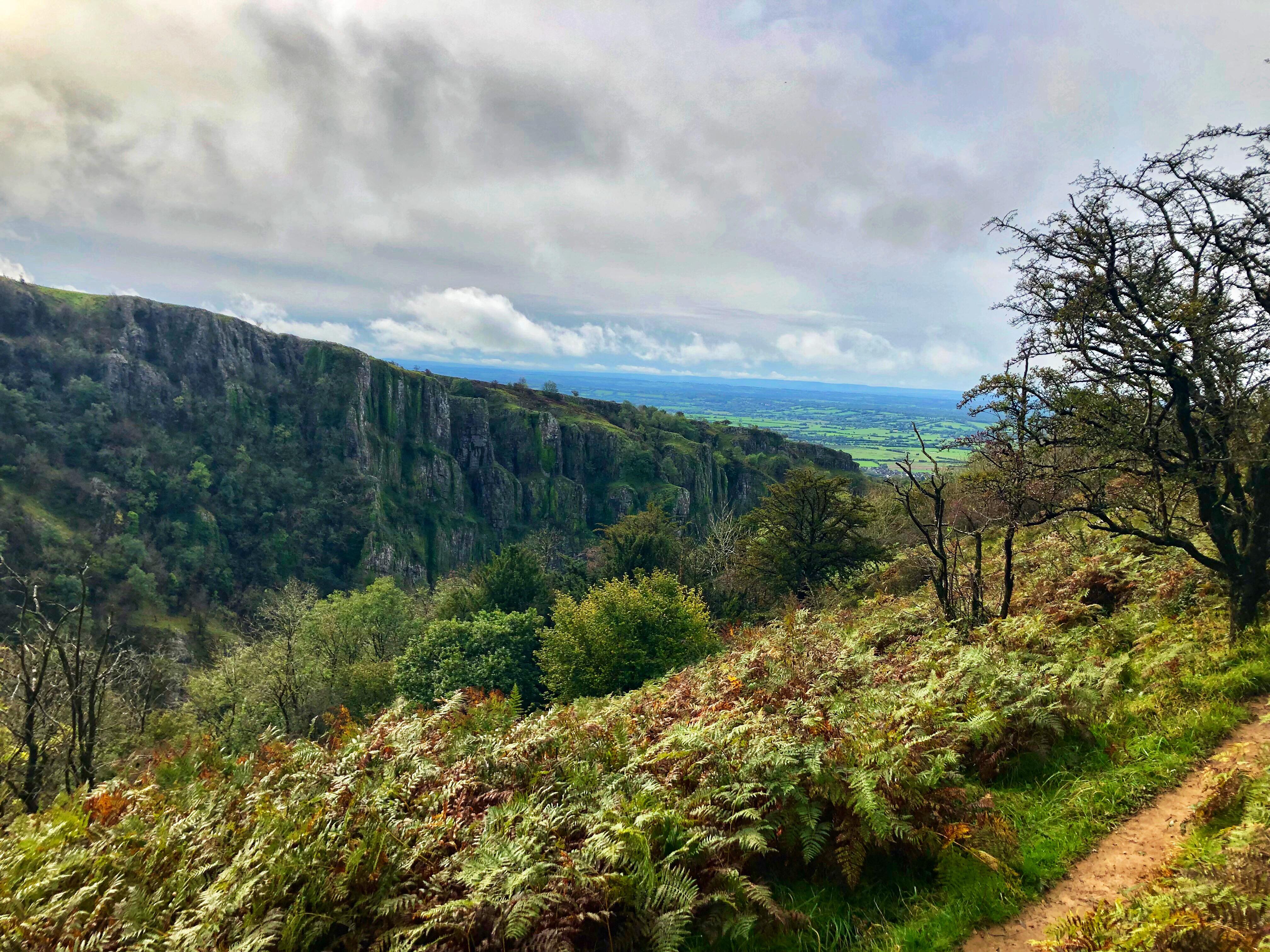
After a sedentary couple of weeks due to the complicated removal of two awkward wisdom teeth, I was twitchy-restless. The weather looked grim so we decided to have a gentle weekend away and travelled the shortish distance to Cheddar Gorge, part of Somerset’s Mendip Hills AONB, on Friday evening.
We found a perfect roadside camping spot between the high walls of the gorge and graced a couple of lovely little pubs with our presence: the Gardeners Arms, a cosy old bar, and the White Hart, which did really good food at really, really good prices.
It rained heavily overnight but was okay by the time we were awake, caffeinated and stocked up with painkillers for my still-chubby cheeks. After a brief wander round Cheddar we set off on a 4-mile hike around the gorge. Starting from the town, we walked up a steep, muddy wooded section to gain the high north edge, then through rugged goat fields along the West Mendip Way.
I laughed at Ryan when he saw a “budgie” fly up from the forest across the gorge, which I suspected was some pale brown bird lit up by the sun but later turned out to be (maybe, I’m 50/50 convinced) a yellowhammer. We descended into a wood crammed with hazelnuts, crossed the road at Black Rock and climbed up the steep wood to the gorge’s long, scrubby, mushroom-scattered south edge.
The vertical limestone faces on this side are without doubt the most impressive part of the gorge, towering over the tiny road that winds through the middle. We wandered onto the huge grass-covered fingers of rock jutting into the shadowy valley, regretting that it was too wet to climb – nice looking, partly bolted rock stretches down for several pitches. There’s something exhilarating and unsettling about how the suddenly the ground drops away here, and I was fixated by the ant-like cars snaking along the pass hundreds of feet below.
This south edge offers the best view of the gorge, which abounds in three things – lush vegetation, rocky outcrops and goats. Funny little coarse-haired faces pop up all over the place, from high up sheer rock faces to roads down in the town. Looking across the valley over the crevasse-like edge, the north bank slopes comparatively gently and is carpeted with scrubby, hardy grass, punctuated by smaller rock faces and wind-beaten bushes. A mixed forest thrives at the shallower top end of the gorge until its arrest on the south side by the huge grey rock faces, too sheer to be penetrated by roots.
The landscape around the gorge is strikingly flat in comparison. Miles of green fields stretch out in all directions, lined by straight hedges and interspersed with clusters of reddish rooves. The perfectly round Cheddar Reservoir and Brent Knoll stand out from the otherwise uninterrupted flatness, and the rough, rugged edges of Cheddar Gorge contrast starkly with its cultivated, inhabited, carefully constructed surroundings.
We climbed down the steps of Jacob’s ladder back to Cheddar town and spent the afternoon/evening buying cheese, drinking cider and playing pub games. Cheddar has a decent variety of shops and (more importantly) drinking establishments – we went from a sports bar to a wild west style saloon to a traditional, cosy pub. Choosing to bypass the hairdressers-by-day, nightclub-by-night, we stumbled back clutching kebabs and chasing goats.
Come Sunday the weather was less agreeable and my chubby, partly toothless face was hurting, so we loitered in the Costa tucked into the side of the gorge before heading to Wells, England’s smallest city. I was keen to see the cathedral and wasn’t disappointed – it’s a vast, beautifully detailed and satisfyingly symmetrical building situated in lovely grounds next to a moated bishop’s palace. There was a food festival thing on so the town was swarming with people, but otherwise it looked old and very pretty. We found a quirky old gaolhouse pub, rehydrated and headed reluctantly home.
NB: we didn’t do any caving due to very wet weather (so much so that some of the commercial caves were shut), one sore face and less disposable income than we’d like, but it’s definitely on the to do list for next time.
One of my favourite camping spots is halfway up the Sugar Loaf side of the Usk Valley, accessible only by narrow, winding roads often blocked by sheep. We arrived about 9pm and spent the rest of the evening doing my favourite kind of relaxing – under a starry sky, cider in hand, van door open, Dire Straits playing and overlooking the streetlight-spangled valley.
The Big Four horseshoe hike
After cooked breakfast and admin (feat. both hobs and a gas burner), we drove to Blaen-y-Glyn and parked at a jaunty angle on a bank. We planned to do the Big Four horseshoe hike, an 8-mile loop which includes the summits of Fan y Big, Cribyn, Pen y Fan and Corn Du.
After an accidental detour into a forest, we set off past a waterfall and up an alarmingly long, steep hill. The path was rocky but well-kept and the view became increasingly impressive as we climbed, with the sweeping ridges stretching in long layers out to the horizon, carpeted by that hardy kind of grass that lives stubbornly on bleak, rugged hills. Eventually the ground levelled out and we followed the path around three sheer sides of a rectangular plateau which forms the easternmost edge of the four horseshoe-shaped ridges.
We walked along the curved ridge of the first horseshoe to Fan y Big (heehee) and decided to skip a photo on the diving board shaped slab of rock. People were congregating with sandwiches and elaborate camera setups, and ain’t nobody got time for queuing when post-hike pub plans have been made. I stopped to tend to a potential blister, then we descended the steep ridge to the base of the ominously steep first section of Cribyn.
We pushed on up the slope, heads down and toes jamming into the soily steps kicked into the hillside by hundreds of stubborn, stampey walkers. I hate stopping for breaks on tough, steep sections, so I ignored my protesting legs and let the pull of a promised pint power me up. The gradient eased as we followed the curve of the second horseshoe to the summit, then plummeted down as we turned towards the distinctive twin tabletop peaks of Pen y Fan and Corn Du.
The section between Cribyn and Pen y Fan is distinctly V-shaped, with a boggy bit in the middle and a long set of steps up to the summit. As expected this was swarming with people and there was a cringe-ily British queue for the 886m sign, which we pointedly ignored. The wind had got up since Cribyn and we hurried along the short, busy ridge to the cairn at the top of Corn Du, past the throng from the Storey Arms “donkey track”, and wasted no time in moving south along the long, straight ridge that runs parallel to the curved ridges of Cribyn and Fan y Big.
The long valley created by the smooth, curved sides of the two parallel ridges contains the now drained Neuadd reservoirs, walled on one side by an imposing, slate-grey gothic dam and encircled by trees. To the south, dark pine forests cover vast sections of the hillsides like creeping shadows. After a long stretch along the Graig Fan Ddu path, we bore left down the steep slope into the belly of the valley, came to the lower Neuadd reservoir, and followed the works diversion across the Taf Fechan river to the edge of Taf Fechan forest.
The path curved round along the edge of the dark treeline, which now revealed an abundant variety of evergreens, conifers, shrubs and flowers. Sheep bumbled around scrubby fields, and although pleasant (-ly flat) the last section along dirt track and road dragged a little – we were well into pub o’clock.
4hours 45mins and 8 miles later, we got back to the van, changed and rushed off to the pretty town of Brecon, where we found a spot to stay overnight. Somehow we ended up in Wetherspoons* and spent the evening quelling hunger and sobriety.
*somehow = £3.60 a pint
MTBing, Forest of Dean
It was too wet to climb on Sunday, so after a quick detour to the National Park visitor centre and a walk round the quaint village of Crickhowell, we headed to the Forest of Dean for a spin on the mountain bikes.
We managed to get lost before we even started and ended up joining the Verderer’s trail (graded blue, intermediate), a 7 mile cross country loop, a few waymarkers past the start. It was mostly well-kept singletrack, with mainly sustained uphill sections to begin with and flowing downhill runs towards the end. It wasn’t too technical, but on a downhill bit with an “adverse” camber my fairly bald front tyre slid out and sent me flying down the bank. I was more concerned for my bike than my scraped left shoulder, arm and leg, but it was fine.
I wasn’t going to mention Ryan’s achey legs but I will, purely for the fact that he was being a fanny and – once we reached the car park where we should have started – decided that he was too tired to complete the loop and ride the couple of hundred metres to where we actually started. Sorry not sorry – the map on my Garmin app has a gap in. But we agreed to come back for longer and complete it next time, along with the Freeminers trail (graded red, experienced), so he was forgiven.
Verdict: 9.5/10, great weekend (-0.5 for the incomplete bike trail)
Last time I went up Lochnagar I couldn’t see a thing for blinding snow, cloud and ice. No crampons, broken compass, zero visibility, precipitous ridge, 10/10 could have died. During a visit to the Cairngorms in May I went up again to see what it looks like.
We started at the Spittal of Glenmuick and went up the same route as last time, following a straightforward gravel track which goes through a greener-than-green wood and up a long, gentle incline. It cuts through a few sweeping miles of high, heather-covered moorland, then becomes a less gentle incline and turns into a slabby path. It gets steeper still and the slabs disappear, leaving hikers to carve their own routes up the scrambley, bouldery rocks. As we climbed snow appeared, thickened, and soon covered everything.
We hiked/scrambled our way along the long, icy, rocky ridge which curves in a C-shape around a bleak, high tarn. The ridge drops precipitously down to the still, black water, exposing an intimidatingly sheer, dark granite face, and as we followed it round I was struck by the distance around the top to the summit. I realised that it was quite a feat to have climbed this munro in the middle of winter with zero visibility and minimal gear.
Eventually we reached the trig point, which stands proudly on a high outcrop, and stopped to gaze dramatically into the distance. We watched the mountains’ reddish-brown heather carpets fade to hazy blues and lilacs as they stretched out to touch the 360degree horizons, interrupted only by snowy peaks, and we could see for tens of miles all round.
I can’t think of a comparable landscape – at least not one that I’ve seen. Mountains often seem to envelop everything, standing high and imposing, shouldering each other as if competing for space. This place is different; equally dramatic, but in an open, rolling, panoramic way. If Glencoe in the Highlands or the Southern Fells of the Lake District are great white sharks, the Cairngorns are blue whales. Majestically vast, gentle and quiet. On a clear day.
We indulged in a picnic of olives, houmous, pitta and other posh bits (I didn’t even have porridge) and a cup of tea at the summit, then headed down the path which rolls over the hump-like southeast side of the ridge and lies parallel to our route up. We headed in the right general direction, then followed the path down along a crystal clear river. The snow retreated as we descended past lush, green vegetation and rushing waterfalls, and we found ourselves in a wood carpeted and roofed with unbelievably bright green foliage on the edge of Loch Muick.
The walk back was long and pleasant, along the flat, birch-lined north bank of Loch Muick. The rich trills of birdsong and the crunch of our gravelly footsteps emphasised the absence of background noise, and if I didn’t have a flight to catch I’d have been lured in for a swim by the still, dark water. We saw a herd of red deer in the open moorland beyond the loch and failed to identify several birds before returning to the pine wood by the car park, de-kitting and driving off [very, very] reluctantly.
With equal reluctance I caught my flight back to Manchester, lungs longing for more mountain air but chest otherwise empty as, once again, I’d left my heart in Scotland.


")


