March 2022: Snowdonia Group Trip – Idwal Slabs, Tryfan, Moel Siabod & Coed y Brenin

Friday 25 March

We were raring to go for a social weekend in North Wales. My old friends Dave and Charley had planned a group trip up with the intention of climbing Tryfan and celebrating Dave’s birthday way back in 2020, which – like most other things in 2020 – was thwarted by covid. Excited by the prospect of a long overdue reunion and double excited by the prospect of a long overdue reunion in the mountains, we were up and on the road by 04:15.

We collected Lee on our way up, another old friend and (as we soon found out) an excellent travelling companion totally unphased by most things, including waking up at silly o’clock to set off on random activities. We had a clear run of traffic and crossed the border by 9am. Concrete and tarmac turned into steep, forested, river-bellied valleys, and we stopped at picturesque Betws-y-Coed (a lovely little town whose praises I’ve sung previously) for a snack and a leg stretch.

From “Betsy” we drove along the familiar A5 for 20 minutes, already feeling absorbed by the thick forests and rugged valley sides that tower over the sweeping road. The sky was clear and the sun was already warm when we reached the roadside car park opposite vast, dark Llyn Ogwen, backed by the hulking mass of yellow-green Pen Yr Ole Wen (which is quite high on my to do list). We threw on our already-packed rucksacks, walked along the road to Ogwen Cottage and went through the gateway to the Glyderau mountain range.

Climbing at Idwal Slabs

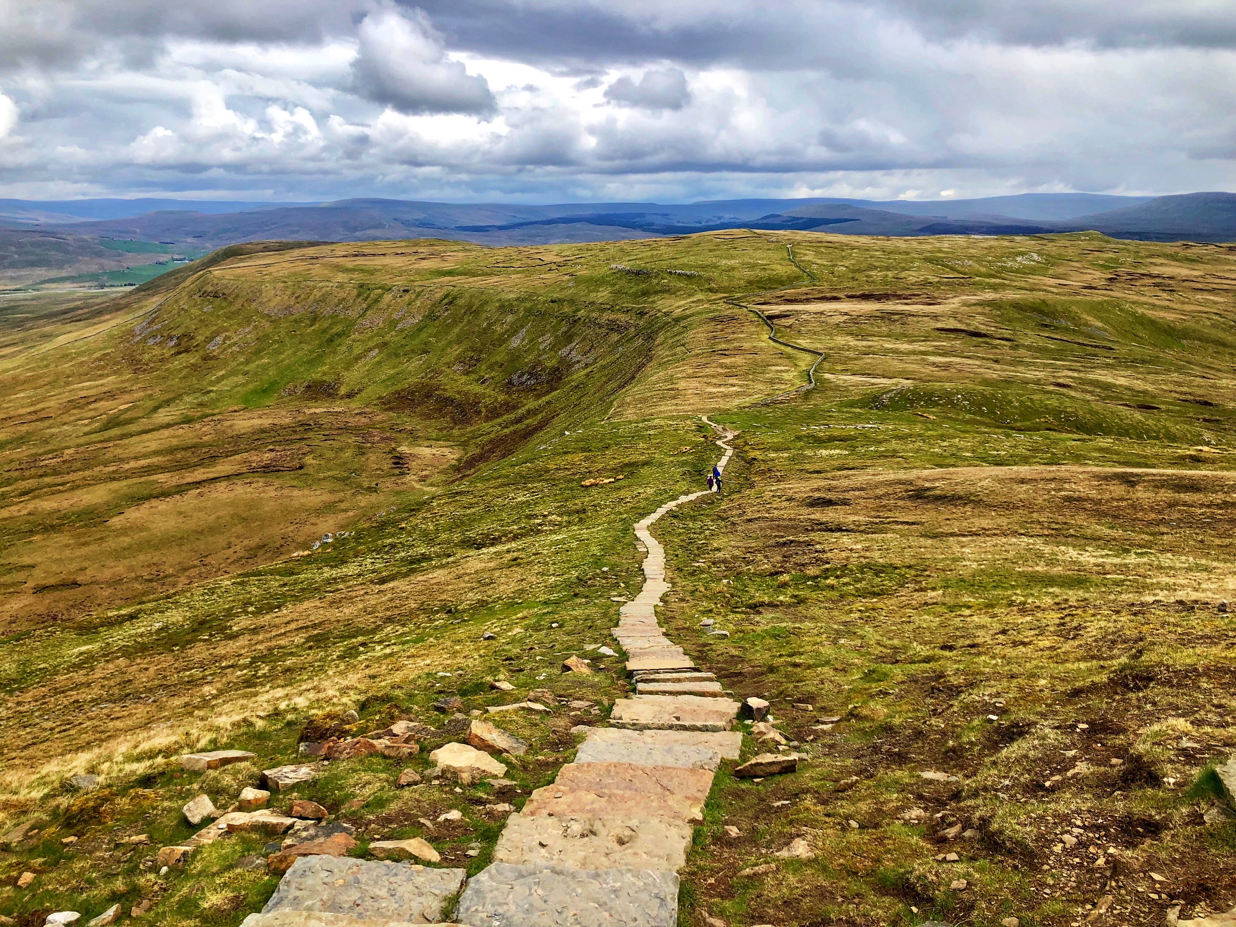
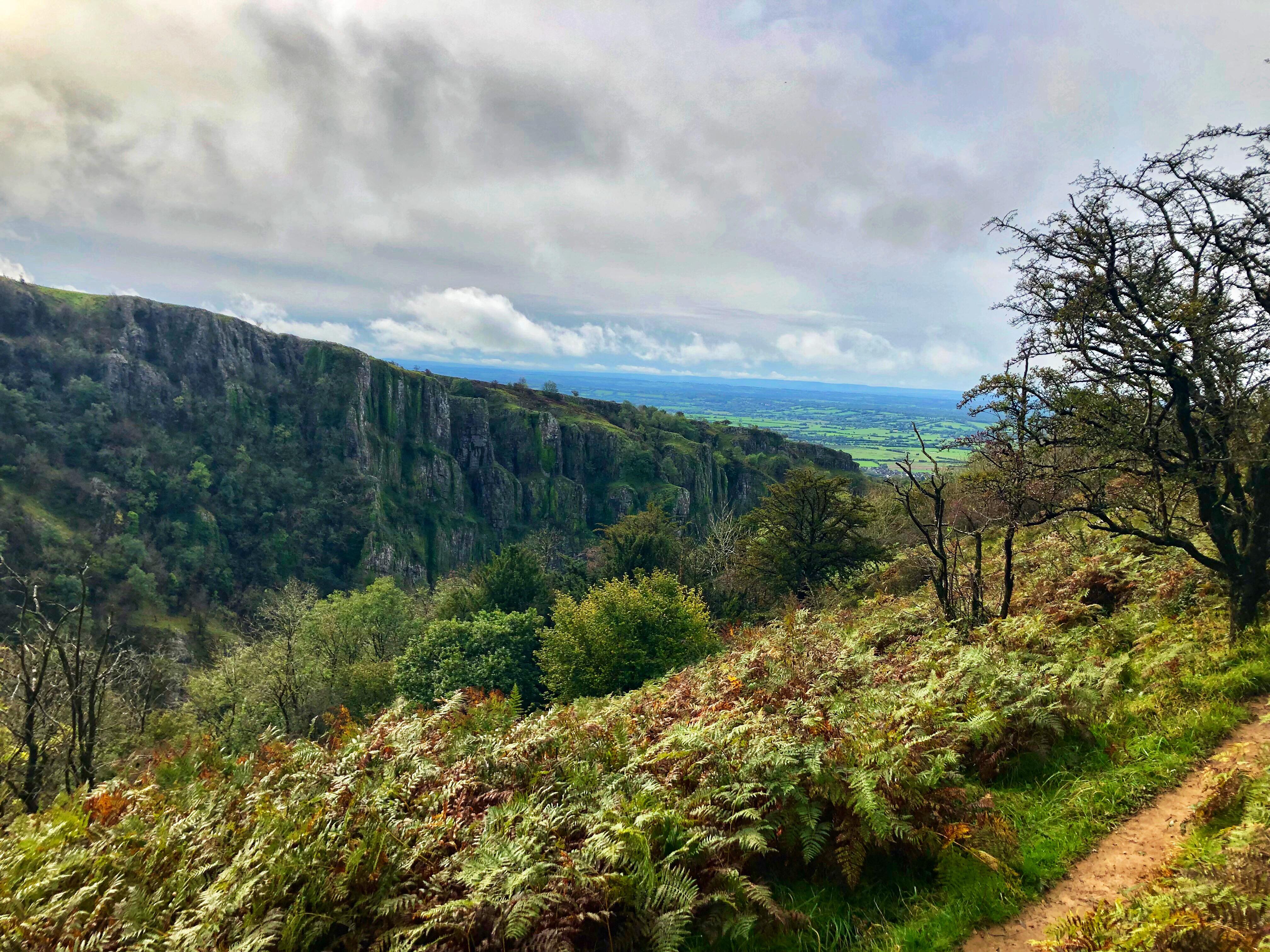
The path up to Llyn Idwal is well-walked and well kept, and we were pleased to pass a big school group enjoying the sunny outdoors. The unmistakeable, stegosaurus-scale form of dark Tryfan dominated the view to our left and the high ridge of Glyder Fach and Glyder Fawr loomed ahead, curving round via the wide, black crack of Devil’s Kitchen to the equally intimidating Y Garn and Foel Goch on the right. The dark, high lake sat thus in a huge, rocky, ancient bowl overlooking the stunning Ogwen Valley. I’ve previously written about this area in more detail – see here for more of that kind of waffle.

Idwal slab is a huge rock face that lies at the head of Llyn Idwal and forms part of the south face of the towering Glyder Fach/Fawr ridge. Its sloping angle, grippy rock and solid cracks makes for good, low grade climbing, so as well as wanting to try it ourselves we thought it’d be good for Lee, who hadn’t really climbed before. We planned to do the classic route “Tennis Shoe” (HS 4b) but there were climbers already on it, so we opted for the easier “The Ordinary Route” (Diff), a “classic” that was recorded as a route way back in 1897.

We roped up and Ryan led the first pitch up a wide, easy crack. Lee followed and I cleaned the gear. Having an extra person was nice because the belayer always had someone to talk to, and I was amazed at how quickly and easily Lee picked it up – I’d been a little worried that a big multi-pitch trad route might be a bit ambitious for a new climber, but I’ve never known anyone so unfazed. Ryan and I alternated leading the route and as we climbed higher, the view of Llyn Idwal and the Ogwen Valley became increasingly impressive and the lake seemed to turn from deep black to a cool blue that contrasted with the bright, sandy yellow of the mountain grass. I could drawl on about the scenery and the captivating wilderness for a long time, but I’ll use some photos instead:

The climbing was straightforward all the way up, with the occasional slightly spicier move, and we didn’t bother changing our approach shoes for climbing shoes. It would have been quite a comfortable free solo until reaching the last couple of pitches and looking down the steep face. The gear placements were generally good (sometimes too good – I spent a good few minutes retrieving one nut) with the occasional weird bare bit where the rock seemed to change, and my last belay point was slightly dubious – I’d got to the end of our 40m rope and ended up pinning myself into an outward-facing seat by slings tightly attached to a nut and a horn either side of me. It was interesting having a third person because we had to choose belay points with space for him to sit or lean, which is something I don’t usually think about.

From the last belay point we scrambled left across less steep but rocky, slightly muddy terrain towards the misleadingly named “walk off”, which took a while to find thanks to the unhelpful description in our Rockfax guide. Eventually we spotted a couple of arrows etched into big rocks and I’m glad we did, as we wouldn’t otherwise have guessed that the way they pointed constituted a “walk”. Fortunately Lee was unfazed once again and we downclimbed a short, steep, rocky scramble that the book suggests is often abseiled. Doing so with a prawn sandwich in one hand probably wasn’t my smartest move, but I’d stopped at the top to put the book back in my bag and came across the irresistible, handy snack.

We reached the bottom unscathed and walked down the sloping bank to rejoin the path alongside Llyn Idwal. We traipsed back to the car the way we came, down the hill that climbs up to Idwal (a glacial “hanging lake” set quite high up), past Ogwen Cottage and a short way along the A5, tempted by a dip in the cool, clear water of Llyn Ogwen and once again blown away by the stunning views and the unbelievably lovely March weather.

A Yaris tour along the North Coast

We left the car park to go and find the holiday cottage via a supermarket. It was six and two threes whether we went back the way we came through Betwys-y-Coed or carried along the A5 and followed the coast around, so we opted for some new scenery and went north west along the valley to the greyish town of Bethesda, then around the top of the national park via the North Wales Expressway, a smooth, wide road that runs along the north coast with the calm, blue sea on one side and hills rising hazily on the other. It felt like we were in a foreign country or a car advert, although poor, peeling Scabbers the Yaris would never make it into one of those.

We stopped at an Asda in Conwy, although it had little right to call itself an Asda – it was barely bigger than a Spar. I was more stressed out by the prospect of shopping than I had been halfway up the rock face, so we collected various fajita ingredients and assorted alcoholic refreshments and scarpered. We found the holiday place about 20 minutes south of Conwy in the middle of nowhere (where nowhere is an agricultural paradise of grassy hills, sprawling fields and long hedgerows), reached via some remarkably steep, narrow, twisty, bumpy country roads.

The House and the Reunion

We rolled onto the wide gravel drive and realised that Charley, the friend who planned the trip, had spoilt us all. We were looking at a beautiful, long, stone barn conversion with a lovely wooden extension and a huge porch. It fronted onto a slate-pebbled yard with lovely countryside views, and had its own open barn containing a hot tub, ping pong table and gas barbecue. It had four double rooms with a shower each, two living areas, a large central kitchen, a fancy staircase, lovely stone floors and a curious way of feeling both cosy and spacious. We saved the master bedroom (complete with balcony and en-suite fit for royalty) for Dave and Charley, Lee took one of the upstairs doubles and Ryan and I had the downstairs double, for alcohol and staircase-related safety reasons on my part.

The three of us unpacked the car and relaxed on comfy sofas until the others arrived. Dave, Charley and Cooper the dalmatian turned up after about an hour, Ryan and I cooked fajitas and we agreed not to drink too much that night – we had to climb Tryfan tomorrow, and it’d be better to save ourselves for Saturday night. Then Matt turned up.

He was earlier than expected and having not seen each other for such a long time (Ryan excepted, who met everyone that day), we must have gotten overexcited because everything took a turn for the worse. Drinks flowed (everywhere) as we caught up with each other, and – although my memory is hazy at best, utterly blank at worst – I think it’s probably a good thing we had the hot tub to contain us.

Saturday 26 March

I woke at 5am on a sofa, which is strange considering Ryan had put me to bed. I woke again about 8am thanks to the delightful sound (which I’ve missed for so long) of Matt cleaning the kitchen. I stood up, fell over for no reason, woke and whinged to Ryan about my bleeding knee, wandered out to say hello to Matt and Dave, and promptly returned to bed. I woke more successfully after about an hour and went to try and make myself useful, although the boys had already removed all traces of Friday night. Someone cooked bacon and somehow we were all in Dave’s car around midday.

The drive to Tryfan was harrowing. There was no avoiding the twisty country roads from the house, but after being on the main road for a while sat nav took us off and along the Gwydyr forest track instead of through Betws-y. It was a sorry excuse for a road, especially in a car full of six hungover people. I’m quite sure it’s the twistiest, bumpiest, narrowest, steepest, roughest road in the whole world, and Charley – who was the worst of all of us – looked like she’d perish at any minute. After about four calendar years we reached the Ogwen Valley and were relieved beyond words to bail out of the car.

Tryfan

Sadly poor Charley was a write-off. She made the sensible (if inevitable) decision that she’d consumed far too much gin to be on a mountain, so the five of us left her in the roadside car park with a window cracked open and trudged off towards the steep north ridge of Tryfan.

The first section involved a lot of rock-hopping and scrambling, and our senses began to clear. The summit is barely a kilometre from the car park as the crow flies and the path follows a fairly straight line, but over 600m of ascent meant that the “walk” was very steep and hands-on, requiring very little progress “across” and a lot of progress “up”. Fortunately there’s no hangover cure like cool mountain air and an imminent risk of death, so we were in good spirits before long. We followed the vague path, guessing the way up every time it stopped at bare rock and taking enough breaks to fully appreciate the incredible views up and down the long, pale golden Ogwen Valley, with dark Llyn Ogwen in its belly, the rugged curve of Y Garn and Foel Goch at its head and lofty Pen yr Ole Wen forming the opposite ridge. We couldn’t have hoped for better weather – the clear skies afforded the best views I’ve ever seen of the Glyderau and Carneddau mountain ranges and the gentle breeze kept us cool.

We stopped at the self-explanatory “cannon” for an obligatory photo, rolled eyes at the false summit and scrambled up the steepening rocks, which became a little exposed on the east side. We hauled ourselves up an extremely photogenic gully, traversed some large gaps and discovered a second cannon, which we decided was even better than the first in that the drop off the edge was much more dangerous, therefore much more irresistible. We decided that standing on it ourselves was fine, but watching the others do the same was extremely nerve-wracking as the faller wouldn’t really have to deal with the catastrophe. Once Matt – probably the most giraffe-like of all of us, and the last one to go up – made his way down from that rock, we all breathed a sigh of relief.

From there it was a fairly short but awkward way along and up, and at the top Adam and Eve appeared like effigies on the rocky summit plateau. Suddenly the view was panoramic and we were delighted, not in the least bit hungover. We did the jump between them to gain the “freedom of Tryfan” (again, watching was much worse than doing, and both were much more comfortable than last time Ryan and I did it in climbing gear and claggy weather), fed off Lee’s magic rucksack full of miscellaneous confectionary, debated why there were eggshells on the ground until deciding that hard boiled eggs are actually an excellent mountain snack, and walked the rocky but less steep and more sociable way down the summit’s sunnier south west face, enjoying the new views over to the Glyder ridge, Y Gribin and the lovely tarn of Llyn Bochlwyd.

The rocky terrain became decidedly boggy and we did our best to avoid the worst bits (especially the deep, sudden, ankle-sized holes) until we reached the well-kept path that goes from Ogwen/Idwal Cottage up to that high lake. We amused each other, notably with stories of snakes, pheasants and bits of badger-related law (thanks Dave), and felt fully recovered from Friday. Eventually the descent levelled out and the walk to Ogwen Cottage was very pleasant, except when – to Matt and Lee’s delight – a passing dog kicked a lump of mud in my hair just as I crouched to examine some frogspawn.

Return

We reached the bottom of the path, grabbed some snacks from the kiosk at the little visitor centre and made our way back along the A5 to Charley, not sure what condition we’d find her in. Luckily sleep had revived her, but the 40 minute drive to a big Tesco near-ish the house was enough to return the rest of us to our sluggish, hungover state, and once again I didn’t enjoy the shop one bit.

Back at the house Dave and Charley cooked lasagne and we spent the evening in a more acceptable way than the previous night, although it did feature the most hectic game of beer/ping pong I’ve ever played (involving six people, five bats, a washing up bowl and ball-repellent cups) and another, more chilled dip in the hot tub.

Sunday 27 March

Moel Siabod

After a lie in and breakfast rolls, we set off about midday for Moel Siabod, a mountain known as a lovely hiking destination that has been on my list for a long time. Once again we drove into the A5 valley through Betws-y, this time parking at the Tyn y Coed pub. We walked a short way along the road, then branched off up a very steep track (a substantial warm up) which eventually brought us to a sheep-spangled moorland covered in high yellow grass. The majestic, sweeping slopes of the mountain lay ahead of us and we enjoyed a near-panoramic view over rugged, rolling peaks, which were broken up into a golden-brown-grey-green patchwork of rock, grass, heather and forest.

Thankfully the path was clear and the gradient eased, so we talked our way up to the base of Moel Siabod’s rocky northeast ridge. A large, dark tarn appeared on our left as the land rose above us on our right, and we continued on feeling a bit fellowship-of-the-ring like until we reached some ruined quarry buildings and a small, deep-looking, almost perfectly round tarn with a sheer back wall. We threw a few stones in (we’re only human) before everyone else’s feeble tosses were put to shame by Lee’s rocket launcher arm, and we carried on along the base of Moel Siabod’s long, steep southeast face through grassy, rocky, heathery terrain until we came to another, larger tarn, Llyn y Foel, the hazy blue-peaked landscape opened up in front of us, and the path disappeared.

After some careful bog avoidance we stopped at the base of the Daear Ddu ridge for a snack, then began the technical part of the ascent. We’d planned to go straight up via Daear Ddu, a grade 1 scramble, but decided at the bottom it’d be safer for us all (especially Cooper) to follow what looked like the more trodden path to the left, which was effectively a scramble up a steep boulderfield away from the ridge’s sheer drop. It was awkward in places, particularly with a slightly nervous dalmatian who wasn’t used to hopping from rock to rock across big, dark gaps, but luckily he was very agile and made it up with some persuasion.

After what felt like a long time we pulled up over the edge of the mountain’s rocky south face onto the summit plateau, which was covered in large lumps of scree and dry, hardy grass. Cooper, who was relieved to be back on solid ground, had the cheek to bound off ahead as if he’d just finished the warm up while the rest of us tramped up to the trig point. Dave in particular did a lot of tramping, as I’d spent a portion of the ascent sneaking rocks into his bag (birthday beats are so 2009), which he only discovered right at the summit. He took it like a champ, and we all gawped at the now fully panoramic view until chilled by the breeze, pointing out the distinctive shapes of Tryfan and Snowdon and the uncountable surrounding peaks, which ranged in colour from hazy grey-blue to golden-yellow to brown and dark green.

The way down was more sociable, involving a walk across to the other side of the plateau, a little bit more scrambling and Cooper-herding across rocks, then joining a clear path through rugged grassland that signified the end of the most awkward terrain. As we made our way down Siabod’s less-steep northwest face the huge, dark blue-lilac forms of the Glyderau mountain range dominated our view to the left and the golden-green Dyffryn Mymbyr valley stretched out ahead of us with its random undulations, which were sometimes rocky, sometimes heathery and sometimes foresty.

We reached an evergreen forest after a long, straight “down” section and only one snack/admire-the-view break. It had that surreal, tranquil quality only found the wildest, remotest woods. Trees, birds, shrubs, spring flowers, mosses, even the stream – everything seemed to thrive in a quiet, old, unimposing way. We walked along the forest track until we reached the bottom of the hill, where the Afon Llugwy flowed white over the fascinating rock formations it had carved. We crossed at an old bridge and walked a short distance along the road back to the cars.

Chinese n Chill

The bar at Tyn y Coed was closed but we made up for it with a drink at Y Stabblau pub in Betws-y-Coed, where we’d eaten after completing the Three Peaks Challenge three years ago. Someone had planted the Chinese takeaway seed which meant the matter was not open for negotiation as we all fancied it so much, so we went back to the house, showered and regrouped in the big kitchen. After some faff trying to find a fairly nearby takeaway that was open and answering the phone, we sent Dave and Ryan off to collect the treasure after what felt like a 10-year wait. That Chinese tasted so good.

Before we ate Charley broke the wonderful news that she’d managed to get the following morning off work, so they could stay the night rather than driving back. We had a lovely evening playing ring of fire and cards against humanity (which was particularly memorable thanks to Matt’s unrepeatable answer to the “you can’t put *blank* inside *blank*” card), talking in the kitchen for ages and polishing off an unholy amount of leftover takeaway. Once again I stumbled into bed, but thankfully this time I managed to stay there all night.

Monday 28 March

Dave and Charley left early and again Matt took the lead on cleaning up the house. We had breakfast, packed up, said bye to Matt and left at 10am. Lee, Ryan and I wanted to make the most of the day without getting home too late, so we headed through the heart of the national park to Coed y Brenin forest park and set off on the 4-mile Gain Waterfall hiking trail (but not before a quick visit to the mountain bike shop and an avowal to come back for those trails another time, having only ridden the blue Minotaur trail previously).

Gain Waterfall trail

It was a lovely, well-marked route along a gravel path that took us through high, fragrant pines, across a shrubby, heathery plain overlooking the distinctive Rhinog mountain range, down a twisty valley and along the fairytale-like Afon Gain and Afon Mawddach rivers. We passed the ruins of an old gold mine and some stunning, high waterfalls which tumbled and rushed into copper-coloured plunge pools. Like the woods on the way down from Moel Siabod it was almost absurdly tranquil and timeless, and neither a dinosaur, a medieval vagabond nor a Victorian gold panner would have looked out of place in the old forest.

Home

After a sandwich and a drink in the visitor centre, we set off home. We talked for the full four or five hours, only stopping once in a pretty town with a funny hybrid petrol station/co-op/garden centre place to get petrol and cannonball-sized scotch eggs, and the sunny drive back through the Welsh/English countryside was way better than the motorway.

All in all a top weekend with top weather, top scenery, top accommodation and top people. 10/10 would recommend.

Alps 2020, Day 6: Aosta Valley, Italy

I’m writing this a year and four months late, which is quite poor even by my timekeeping standards. A lot has happened since then (global pandemics etc) and other diversions have meant that I’ve neglected my blog terribly, so consider this my effort to catch up.

We woke in our cosy Italian Air BnB, breakfasted on cereal, made coffee on the hob with a saucepan and ladle (no kettles in Italy) and drove off to find somewhere to hike. I can’t remember why we went where we did – maybe we Googled local hiking spots – but after a short drive we ended up parking in a pull-in halfway up the side of a mountainous valley. The weather was kind of grey and snowy, but visibility wasn’t too bad and we loved the remoteness of the location.

We waded through deep snow towards a forest, following what vaguely resembled a path. When we reached the trees it was as if we were transported into a winter fairytale. Dark green firs, pines and spruces towered above us, branches laden with thick snow, and as we got further in the tracks faded and the white ground ahead became pristine. It felt like we were the first people to ever set foot in the forest.

We played around, shaking snow from branches, throwing snowballs, falling over, climbing bits of rock, drinking from a stream and shuffling along the trunk of a fallen tree. It was surreal, like noone else existed. We ate feta and salad sandwiches under the shelter of a rock and, childish impulses satisfied, headed back to the car the same way we came.

I drove cautiously along the winding roads, down the side of the valley and into the town of Aosta. After a brief altercation with an uncooperative, non-English speaking parking meter, we managed to get a ticket and wander round the town. Neither of us had been to Italy before so we found it really interesting.

Aosta is an ancient place which has largely retained its Roman foundations, including thick city walls, an amphitheatre, some old gates and a regular, blocky street plan. On approaching the centre we walked through a couple of stone arches and were bemused by the juxtaposition of thousands-of-years-old architecture with modern, raised walkways and handrails. Despite this contrast the town didn’t feel fragmented or piecemeal in any way – it felt simultaneously old and new, “then” and “now” inextricably woven together and brought to life by a vibrant buzz of people, flags and shop fronts. We weaved along cobbled streets lined by four and five story buildings painted yellow, orange and beige, populated by all kinds of shops and pizza, pasta and gelato places.

We left the buzzing high streets and found the cathedral, a towering neo-classical building fronted by tall white columns topped by intricate carvings of crucifixes, wreaths, figures, books and ornaments. Set back under the large front arch is a wood panelled door surrounded by a colourful display of painted biblical scenes, framed by golden columns and another arch containing delicate statues with painted robes and faces cast upwards. I cant do it justice with few words, so here’s a picture:

We explored the side streets, intrigued by intricate architectural details and the simple, timeless elegance of the place. Snow-scattered, mountainous valley sides rose above rooves and chimneys, giving the town a self-contained, cosy feel, and statues (notably of Neptune, huge trident in hand), arches and an abundance of churches hinted at Aosta’s long, rich history.

We wandered back to the car feeling satisfied with our cultural immersion, only to find some paperwork under the windscreen wipers and a couple of police officers lingering on the street. Hearts sinking, we realised that the road was being closed for the “Fiera di Sant’Orso”, some kind of festival that had been advertised on banners around the town but which we’d paid no attention to, nor had we seen road signs warning of closures (not that we’d have understood them anyway). One of the police officers said something semi-irately in Italian, to which we replied quite uncomprehendingly in English, and she took back the paperwork and let us drive away after a bit of gesturing and what was probably a bit of a telling off.*

A 20-minute drive through the valley took us back to the Air BnB, where we had a camembert snack and researched places to go for dinner. We wanted to try proper Italian pizza and we found a pizzeria called Le Vieux Bourg in a small town called Etroubles, 15 minutes from the apartment. We got there about 7pm, found a tiny shop and picked up a couple of cartons of €2.30 wine (always classy) for later, then waded through snow to get to the restaurant.

I’ve never had pizza like it. It was perfect – a thin, light base, just the right amount of tomato sauce, melty, gooey cheese, perfectly cooked toppings and not greasy at all. I had the “Twin Peaks” (sausage and onion, I think) solely because I liked the name, and Ryan had something meaty. Prices were very reasonable – more than passable wine at €2 a glass – and the waiter was friendly, as well as English-speaking. We had gelato for dessert, which we didn’t need as the pizzas were so big, but we wanted to try it and it was also very good. I can’t emphasise enough how good the pizza was, we still think about it to this day. 10/10 would recommend. I’ll stop now as I’m getting hungry.

I drove us back to the apartment and we spent our last night in Italy drinking cheap wine and trying to get over how good the pizza was. We like Italy.

* We’ve since received a parking fine in the post (14 months later) which we’re contesting. Fun & games.

Ben Macdui, Cairn Gorm & Loch Morlich: Scotland day 6, Sep ’20

We had heard from Ryan’s dad how difficult Ben Macdui could be to navigate in poor conditions, so we set off around 8:30am from the Cairngorm Mountain upper car park. It was clear and dry but the clouds hung like a heavy, grey blanket just above the tips of the distant peaks behind us. To our left was a short valley headed by a ridge of bare rock towering over a small loch, Coire an Lochain, and in front was a vast expanse of brown heather and rock-strewn, yellow-gold grass, ascending gradually towards the high horizon that hid the great plateau of Ben Macdui.

The mountain lay directly south of the car park and the walk-in was long and gentle. Because the Cairngorm peaks perch on a plateau that already rises way above sea level, they don’t have the jagged drama of the western mountains and they’re generally more walkable. The gravel path was easy to follow for the first 3 or 4 miles (obviously a different story in snow), until the ground turned from grassy moorland to boulderfields. We hopped from rock to rock, reassured by the occasional cairn. The last mile was steeper and as we climbed the fog thickened, so we were glad for the many cairns that led up to the summit.

There were lots of little rock shelters at the top and after a quick trig point photo (10:30am), we huddled into one and made a brew. As is often the case with high, beautiful places, the fog ruined all our chances of appreciating the landscape and allowed us a view only of the barren, flat, rock-strewn top of the mountain. It felt like we had walked onto another planet.

We headed back down the way we came and when the steep bit levelled out, we took a right fork along a new path towards Cairn Gorm. The fog cleared as we walked past the high, glassy Lochan Buidhe, and we enjoyed a leisurely stroll for the next 2 miles along relatively flat ground. We looked back at Ben Macdui and saw that the cloud had lifted, revealing its dark, hulking peak peering over the vast expanse of yellow-brown, open land, backed by similar dark summits and veined with rivers reflecting the white cloud above.

Looking towards Cairn Gorm (over the hill on the left)

We walked along the rocky ridge that towers above Coire an Sneachda with the grassy plain on our right and a sheer drop down bare rock to our left. The last 500m up Cairn Gorm were very steep and rocky, and we summited about 1pm. At the top sits a big cairn and a weather station, which consists of a small scaffold tower with some metal contraptions sticking out of it and a big black cylinder on a raised platform. It was quite busy as a lot of people walked to the top and back from the car park, so we didn’t hang around, although the view was lovely – panoramic, the horizon formed on all sides by rolling blue mountains.

We descended the steep-ish path north past the Ptarmigan centre and the ski lift, keeping a hopeful eye out as Ryan wanted to see a ptarmigan. Sadly the rocky, heathery ground was birdless. We finished our circular route back at the van around 2pm, had a quick nose in the visitor centre (which was largely closed due to covid) and decided to head down to Loch Morlich in the Glenmore valley for a swim.

We had set aside the whole day for our hike as we’d expected navigation to be a lot more difficult than it was, so I was happy to fit a quick swim in. There were signs at Loch Morlich warning of blue-green algae, but having been exposed without any effects before I decided to swim anyway. I wasn’t in the water for long as I was hungry and still a little wary of the algae (and the duck poo – I found myself in the middle of a flock), but the cold was exhilarating. The worst bit was peeling off my wetsuit in the car park as I shivered myself dry.

Ryan wanted to camp in the same place as we had the previous night, but that was on a dead-end road and as we’d ticked Ben Macdui off I wanted to explore somewhere else. After a brief “negotiation” we decided to grab some supplies from Aviemore and take the A939 road that runs south down the east side of the Cairngorms so we could see the town of Braemar and perhaps climb Lochnagar. The drive was lovely, and after an hour or so we found a good overnight spot at a quarry just outside the village of Tomintoul.

On our customary poke around we found a sculpture on a hill above the quarry, which was like a 3D mirrored picture frame a couple of metres deep that framed the pretty hills behind it. We had tinned chicken in white wine sauce (surprisingly good), rice and veg for dinner, and my highlight of the evening was Ryan returning from a toilet trip with reports of swooping owls and screeching rabbits, and one soggy foot from the only boggy ground in the vicinity.

Lakes Rampage 2020, Day 3: Six Summits

Monday 6th July 2020

Scafell Pike, Great End, Esk Pike, Bow Fell, Crinkle Crags, Sca Fell

This was one of those rare days that I know for certain I’ll never forget. It started innocuously enough, with Ryan cooking breakfast and me making sandwiches at our camping spot on the edge of Wast Water, overlooked by the rugged, imposing mountains and ridges of the Wasdale valley. We knew it’d be a long one as our route encompassed six summits, a lot of miles and a serious amount of elevation gain. Bags packed and bodies fuelled, we drove to the car park at Wasdale Head and set off at 10am.

Scafell Pike, 978m. Summited 11:55

The path began in the lowest point of the valley, just 80m above sea level. It crossed a wide, shallow river, Lingmell Beck, before climbing a little way up the side of a high, grassy ridge, Lingmell. It followed the contour of this ridge through scrubby sheep territory until we rounded the corner, at which point the sheer, dark west face of Scafell Pike emerged at the head of an immense valley. Lingmell Gill flowed high and fast on our right and we followed the path alongside it until the rocky crossing, which wasn’t particularly crossable due to the rainfall. A few hikers had gone quite a way upstream before crossing and heading back down to regain the path, but we didn’t go far before hopping across five or six sturdy-ish looking rocks in an ungainly (but dry) manner and continuing up the mountain.

The rocky path led the way clearly up Brown Tongue which, as well as the multitude of other hikers and my vague memory of the route, made the map redundant for the time being. We took the left fork and approached the summit from its northwest side, the slightly longer but more popular approach. From the fork, going as the crow flies to the summit would have necessitated a serious multipitch rock climb up its ominously sheer west face, which gives the mountain its wild, dangerous appearance.

Our legs were already feeling slightly sore from flying up and down the Old Man of Coniston (803m) the previous day, and I’d forgotten that although popular, the path up Scafell Pike is surprisingly long and steep. Shortly after taking the fork we were hit by a sudden heavy rainshower, which – as they always are, once you’ve committed to getting wet – was exhilarating. We pulled waterproofs on, snapped a couple of pictures and carried on, turning right up the steep, scree-covered path that leads to the summit. The clouds were stubborn but intermittent, and we had our fill of the stunning, rolling mountain scenery in glimpses as we made our way up.

The top section is pretty much a huge pile of jagged rocks, as if the tip of the mountain has been shattered into millions of pieces. At the summit is a trig point and a raised war memorial, and we delighted at being the highest two people on English soil for a minute before finding a sheltered spot for a sandwich. Although perfectly warm when we were moving, our sweaty backs got cold quite quickly in the bitter mountain wind so we took a compass bearing to ensure we were heading for Great End and descended the awkwardly boulder-strewn, loose northeast side of Scafell Pike.

Great End, 910m. Summited 13:06

The cloud subsided when we reached the trough of the col between Scafell Pike and Broad Crag, the mini-top just before Great End. The path to Great End was fairly steep and quite direct, although when it came to branching off the path towards Esk Pike for the actual summit Ryan took us an unecessarily awkward way over a series of rocks. We pulled out the Jetboil and had a brew at the wind shelter on the summit, wondered at the panoramic views and seemingly endless mountains and descended the proper way back to the main path.

Esk Pike, 885m. Summited 14:02

Esk Pike wasn’t easily discernible as the ground on the east of Scafell Pike is all quite high and the rocky ridges and summits seem to merge together. Experience has taught me to be wary of paths as they often look obvious on a map, but much less so on rocky ground where everything is the same colour, and it was around this point that I commented on how the path thus far was suspiciously clear and well-marked by plenty of cairns.

Bowfell, 902m. Summited 14:47

Next up was Bowfell, which had a more obvious summit as there was a group of people having lunch on it. For some reason I remember the scenery here being particularly unforgettable, even though we’d been fortunate enough to have a clear view of the surrounding mountains since before Great End.

The nearer peaks were rugged and olive green, and all had unique shapes with sides that occasionally fell away to reveal sheer, unvegetated rock faces. They weren’t jagged like the gargantuan mountains of Patagonia or the Himalayas – in fact they’re not even comparable – but they had their own wild, majestic kind of beauty. Rivers ran like tiny veins far below in the steep-sided valleys, some so perfectly U-shaped it was as if they were carved out with a giant ice cream scoop, and the mountains further away glowed in mysterious, hazy layers of grey-blue. This is perhaps what I love most about the Lake District: it’s the only place in England where I feel truly immersed in the mountains. I can’t imagine how incredible it must have been up here before hiking became popular and there were no paths scratched into the surface or bright down jackets pock-marking the wilderness.

Crinkle Crags, 859m. Summited 15:51

Crinkle Crags was a bit disheartening because gaining the summit would mean scrambling up a rocky path a kilometre long, starting at the unimaginatively named Three Tarns, only to scramble back down the same way and continue our route. Ry insisted that he wanted to do it despite his knee hurting a little, so we went up the now-elusive path-come-series of rocky scrambles and after what seemed like an age, arrived at the (also unimaginatively named) Pile of Stones marking the summit.

This is where the real fun started (English for where it all went wrong). We looked across two wide valleys towards Sca Fell and it looked terrifyingly far away, leering at us from the horizon. Ryan suggested that if we descend Crinkle Crags off-piste, we should hit the footpath we were aiming for low down in the first valley which would take us parallel to and then across a river, and we would then walk [a really long way] to the base of Sca Fell on flat terrain. This would remove the need to turn back along the annoyingly rocky and long path we’d just come along. He was correct and I agreed – indeed, we should have hit that footpath by the river.

The descent was pretty sketchy, super-steep and more of a downclimb in places via huge boulders, mini waterfalls and loose, scrubby bits of ground. We were careful not to disturb vegetation, rocks or sheep, and although I was inwardly questioning our decision, it was kind of thrilling to be off the beaten track. I was super happy to discover some bilberry bushes (bilberries are like small, sweet wild blueberries) as I’d always wanted to find some but never had before, so my fruity mid-descent snack perked me up.

The Trough, 350m ish

This section deserves its own sub-heading because it would unfair (on the mountain) to attribute it to a mountain. It was a trough in both senses of the word – the low bit between peaks, and a sustained dip in the extent to which the hike was going as planned. As they say, peaks and troughs.

After what seemed like an age we reached the bottom of the treacherous descent down Crinkle Crags, only to discover that the footpath we had hoped to join was untrodden to the point of non-existence. Instead we were met by soft, tufty, awkward ground covered in long, yellow grass. In the absence of a path and an obvious place to cross Lingcove Beck, we looked at the map and decided that the best course of action would be to walk south parallel to the river until we came to the fork, where we would join another path that runs alongside the other branch – the River Esk – to the base of Sca Fell. It would extend our route by a couple of long, slow miles over difficult terrain, but at least we’d be certain of where we are and that we could cross both rivers.

This was frustrating enough, so when my left foot punched through a hole in the ground and into over-the-top-of-my-boot deep muddy water, I became tetchy. After a couple of hundred metres of tramping with one wet foot through boggy ground in an exasperated sulk, it dawned on me that I’d only eaten half a sandwich, half a bag of mini cheddars, an apple, half a flapjack and a few bilberries. We wanted to press on but I self-diagnosed myself as hangry, so we stopped and munched a whole sandwich each. It tasted incredible and I perked up magnificently.

We maintained our course by keeping Lingcove Beck on our right hand side, which took a long time because of the awkward, soggy ground, occasionally picking up scraps of what looked like they could once have been path. Eventually we reached a stone bridge at the fork we were aiming for, glad to finally cross the river and start walking towards, rather than away from, Sca Fell. This time we kept the River Esk on our left, relieved that we were now following a clear path.

The first bit was steep, then it levelled out and we walked for a mile or so across a great, open plain in the belly of the valley between the towering ridges. The path was better than the previous one although ambiguous in places, so we kept a close eye on the map, noting the shape of the river, the contours around us and the bits of drystone wall marked down as boundaries. Unhelpfully, the path disappeared at the river crossing. We’d hoped for some rudimentary stepping stones, but there was nothing. The river was about eight paces wide and higher and faster than usual, and we followed it upstream in search of a way across for 20 minutes or so. Eventually we accepted that our feet were wet anyway and committed to a crossing place that was far from ideal but slightly less terrible than some other places and hopped across.

Sca Fell, 964m. Summited 20:17

We tramped across pathless ground to a long waterfall leading up Sca Fell, which was a mile away as the crow flies. The next section was a steep scramble up a dubiously labelled footpath, keeping the waterfall/river on our left. It was tough going but good to gain height as it made us feel closer to finishing the day. We got to a crossing place and stopped to make a decision. We could either cross the river and approach Sca Fell from the south, carry on along the clear path and approach it from the west – which would mean branching off left and going up and down the same way – or call it a day and continue on the same path, which would take us safely through the col between Sca Fell and Scafell Pike and back to the van, potentially with time for a drink in the pub.

We were tired, hungry and at risk of losing light, but stubbornness prevailed and we crossed the narrow, rushing river, hopeful of completing a circular route up and down the mountain. It looked as if there was a path on the other side, but this quickly disappeared and we were once again tramping through the wilderness. We knew the approximate direction of Sca Fell and we knew we had to do a lot more “up”, so we made a beeline for a high, steep scree slope on our right hand side.

This was one of the crippling low points of the day. The terrain was very rough (scrubby vegetation interspersed with loose rocks), we were exhausted, our phones were nearly dead, the summit was an uncertain, invisible concept beyond a serious amount of elevation gain on poor ground and there was a real risk that we’d lose daylight. We had everything we needed – headtorches, an emergency bivvy shelter, warm clothes, foil blankets and porridge – but we were damp, hungry and determined to get back to the van.

On either side of the scree slope were high rock faces and from a distance it looked as though a figure of a person was suspended from one of them. At first it looked like someone leaning back and taking a photo of something higher up, then it looked like a climber who had  reached the top of a route, then it looked like someone hanging there eerily limp, as if they’d fallen and been caught by the rope. It’s funny how the mind plays tricks when you’re tired, as it turned out to be just a black, figure-shaped void between two slabs.

The scree slope took forever to reach, and once there it was even more terrible than we thought. I did something very unusual: I pulled out my last-resort snacks, an energy gel each, in a desperate attempt to boost us up the terrifyingly steep ascent. The scree was mostly saucer-to-dinnerplate sized reddish-grey rock, and I was careful not to climb above Ryan as I could have sent a rock tumbling down on him at any time. It took just about all our strength to reach the top, and I was almost too exhausted to feel relieved by the sight of the landscape opening out in front of me as I pulled over the brow.

We turned right and headed along the high ridge, relieved to be on more manageable terrain but uncertain exactly how far it was to the summit. Our phones pinged as we received signal for the first time in a few hours, but we were both on 1% so couldn’t faff around taking photos. The scenery either side of the ridge was beautiful, hazy in the fading light, but we didn’t appreciate it as much as usual. The ground got rockier and we finally came to the pile of stones and crude rock shelter that marks the summit of Sca Fell at 8.17pm. It was a huge relief to finally conquer this last peak, the bleakest and wildest of them all, after it had tormented us for the age that had passed since Crinkle Crags.

Return

It wasn’t over yet as we still needed to get on the path back before losing light. It’s common knowledge among mountaineers that most accidents happen on the way down, so we were careful not to get reckless. We descended down the path north east of the summit, which was once again ridiculously steep but this time marked by the odd cairn. It was a relief to be going down but our knees weren’t having a great time, and we half-slid down the loose slope. The path then bore left at the tiny Foxes Tarn and took us literally down a small river/waterfall, balancing on wet, slippery rock on whichever side of the water looked least treacherous.

Once we were at the bottom, miraculously intact, we munched our last snack bar and looked exasperatedly to our left at the next rocky slope we were required to climb to gain Mickledore, the col between Sca Fell and Scafell Pike. It was almost funny, and we just got on with the slow, awkward drag to the top, trying to keep on the vague, loose, steep, zig-zagging path. My concern was that the path over the col on this side of Scafell Pike wouldn’t be obvious (or even in existence) as I took this route the first time I climbed the mountain in 2014, and I remember scrabbling up a steep, scree-covered slope in claggy conditions following no obvious path and hoping for a cairn to appear through the fog. If this was the case, there was a risk that it’d get too dark to navigate and we’d have to bear a cold, damp, rocky night out.

At last we reached the top of the slope and spotted the emergency metal shelter on the ridge up to Scafell Pike. Its straight sided boxiness looked very strange against the rocky backdrop, having seen nothing but natural, jagged shapes all day. Then we experienced the best feeling in the world: pulling up over the lip of the col at Mickeldore. All of a sudden we could clearly see the path that would lead us back, and my concern evaporated. The world seemed to open out in front of us. We had Sca Fell on our left, Scafell Pike on our right, and in front was the vast valley that we’d hiked up eleven hours earlier. We could see the fork where our footpath met the path that we’d taken left up the other side of Scafell Pike that morning, the sun was low, and there wasn’t another person in sight.

We descended down the steep scree slope (see the pattern emerging?) that was the top of the footpath and gained slightly more level terrain, happy in the knowledge that there was no more up. The sun broke through the hazy clouds and glowed a magnificent, warm orange ahead of us, which illuminated the valley and accentuated the wild beauty of every rough, rocky, rugged corner. It felt like nature’s way of saying well done, you did it. I’ll never, ever forget that moment. The walk back along the strangely solid path was slow and unlike my vivid memories of earlier that day, I remember it vaguely as if it were a dream. We talked all the way back to the van, but I have no idea what we talked about.

We followed the path round to the right at the end of the valley, the same way we’d come up, through the steep sheep fields of Lingmell in dwindling light. We didn’t quite need to pull out the torches because the path was good, but it was dark by the time we reached the flat field and river at the bottom. We got back to the van at 10.30pm, equal parts exhausted, triumphant and famished, drove ten minutes to last night’s camping spot near Wast Water, and didn’t have the energy to cook stir fry so ate tinned soup, bread and cheese. Nothing has ever tasted so good.

Dartmoor, October ’19

We left for Devon on Friday evening, undeterred by the miserable forecast and keen to escape the week. After a drink in the Ring O’Bells at Chagford and a sketchy drive along some flooded back roads (sketchy because of the flooding, not the drink), we spent the night in an empty roadside car park on the moors near the Warren House Inn. The wind howled outside and sideways-rain thrashed relentlessly at the windows, making the van extra cosy and the thought of a Saturday hike extra unappealing.

Fortunately the 9am England vs New Zealand World Cup semi-final provided a watertight excuse to chill out in the van. That morning I discovered the best way to watch rugby: tucked in bed, coffee in hand, storm raging outside, on a phone held by two karabiners onto a bungee cord strung across the ceiling of the van. For those 80 minutes the world was perfect, and England’s 19-7 victory topped it off with icing and a cherry.

Reluctant to waste the day, we drove across the bleak, blustery moor. I’d hoped to wander over the old clapper bridge at Postbridge but it was flooded, so we went on to Princetown and went round Dartmoor Prison museum. The prison itself is a foreboding, horror film-esque building, but that morning it was swallowed and obscured by oppressive, thick grey fog. The museum was really interesting; highlights included escape stories, improvised weapons, cleverly concealed contraband and all sorts of prison-made matchstick models.

The weather was still grim so we wandered round the National Park visitor centre, turned down a (strangely?) friendly shopkeeper’s invite to a Halloween party, found a good overnight spot in Princetown, chilled out in the van for a while, planned Sunday’s hike and spent the evening eating and drinking in the cosy Plume of Feathers pub. I assume we had a good time as I don’t remember returning to the van.

We were up quite early on Sunday morning, thanks in part to the clocks going back. We watched South Africa beat Wales during breakfast at the Fox Tor café, a buzzing little outdoorsey hostel/café in Princetown, and plodded (mild hangovers prevented exuberant movement) out onto the moors to make the most of the dry weather.

I’d plotted a rough route by circling tors on the map and joining them up. We walked past the towering Princetown TV mast along a long stretch of bridleway, then scrambled down a rocky edge into disused Foggintor quarry. This is a big granite playground containing a lake, lots of bouldering/climbing/scrambling/camping potential and a few sheep bones. After messing around like children we carried on to King’s Tor as the crow flies, which involved scrambling down a huge pile of boulders and wading through knee-high tufts of boggy grass.

It was pleasantly dry at the top of the hill and we scrambled over the tor, admiring the view. Rugged moorland surrounded us on three sides, punctuated by granite tors which towered like huge stacks of elephant poo, and in front rolling countryside marked the edge of the National Park. We climbed down and carried on, following a curved track once used by quarry carts round to Ingra Tor. After a bit more scrambling we bore east and headed uphill past a group of hardy-looking Dartmoor ponies towards the scree-sided Sharpitor, but it was a little out the way and looked pretty similar to the other elephant poos so we turned left at the B3212 and headed back towards Princetown.

This section took us parallel to a slab-lined stream which we’ve decided to revisit in summer – it’s practically wasted as a water supply as it’d make a perfect lazy river. We walked along this low-lying bit of moor, past dark fir forest, reddish ferns and scrubby bushes, found a tucked-away spot by a waterfall for next time’s pre-lazy river camping, and climbed the gradual slope up to Hart Tor. Here the surrounding moorland is covered by rippling golden grass which touches the horizon on three sides, broken only by the blue haze silhouette of Sharpitor and Tryfan-shaped Leather Tor to the southwest. View admired and Hart Tor being our last circle on the map, we descended across the wild, yellowey moor and followed the road back into Princetown.

So far I’ve failed to mention my idiocy the previous afternoon, perhaps in the hope that anyone reading has got bored by now. I had been enjoying van’n’chill so much that time spent listening to music with the ignition on had flown by and drained the battery. We realised this on Saturday but prioritised the pub (which I do not regret), so we were left with the job of organising a jump start post-hike. I was devastated to find out that a) we couldn’t jump the main battery with the leisure one, and b) my breakdown cover doesn’t cover campervans, but found an alternative service (Kev from Plymouth) which arrived quickly and sorted the problem.*

And so we left Dartmoor, half ashamed, half amused, fully satisfied with a lovely weekend (despite the weather) and fully disappointed that it was over.

*NB – I’ve since written to the insurance provider and received a full refund plus the cost of Kev’s callout, so you can sleep tonight knowing that justice was served.

Cheddar Gorge, October ’19

After a sedentary couple of weeks due to the complicated removal of two awkward wisdom teeth, I was twitchy-restless. The weather looked grim so we decided to have a gentle weekend away and travelled the shortish distance to Cheddar Gorge, part of Somerset’s Mendip Hills AONB, on Friday evening.

We found a perfect roadside camping spot between the high walls of the gorge and graced a couple of lovely little pubs with our presence: the Gardeners Arms, a cosy old bar, and the White Hart, which did really good food at really, really good prices.

It rained heavily overnight but was okay by the time we were awake, caffeinated and stocked up with painkillers for my still-chubby cheeks. After a brief wander round Cheddar we set off on a 4-mile hike around the gorge. Starting from the town, we walked up a steep, muddy wooded section to gain the high north edge, then through rugged goat fields along the West Mendip Way.

73482766_429838307940953_1386903308483952640_n

I laughed at Ryan when he saw a “budgie” fly up from the forest across the gorge, which I suspected was some pale brown bird lit up by the sun but later turned out to be (maybe, I’m 50/50 convinced) a yellowhammer. We descended into a wood crammed with hazelnuts, crossed the road at Black Rock and climbed up the steep wood to the gorge’s long, scrubby, mushroom-scattered south edge.

The vertical limestone faces on this side are without doubt the most impressive part of the gorge, towering over the tiny road that winds through the middle. We wandered onto the huge grass-covered fingers of rock jutting into the shadowy valley, regretting that it was too wet to climb – nice looking, partly bolted rock stretches down for several pitches. There’s something exhilarating and unsettling about how the suddenly the ground drops away here, and I was fixated by the ant-like cars snaking along the pass hundreds of feet below.

This south edge offers the best view of the gorge, which abounds in three things – lush vegetation, rocky outcrops and goats. Funny little coarse-haired faces pop up all over the place, from high up sheer rock faces to roads down in the town. Looking across the valley over the crevasse-like edge, the north bank slopes comparatively gently and is carpeted with scrubby, hardy grass, punctuated by smaller rock faces and wind-beaten bushes. A mixed forest thrives at the shallower top end of the gorge until its arrest on the south side by the huge grey rock faces, too sheer to be penetrated by roots.

The landscape around the gorge is strikingly flat in comparison. Miles of green fields stretch out in all directions, lined by straight hedges and interspersed with clusters of reddish rooves. The perfectly round Cheddar Reservoir and Brent Knoll stand out from the otherwise uninterrupted flatness, and the rough, rugged edges of Cheddar Gorge contrast starkly with its cultivated, inhabited, carefully constructed surroundings.

We climbed down the steps of Jacob’s ladder back to Cheddar town and spent the afternoon/evening buying cheese, drinking cider and playing pub games. Cheddar has a decent variety of shops and (more importantly) drinking establishments – we went from a sports bar to a wild west style saloon to a traditional, cosy pub. Choosing to bypass the hairdressers-by-day, nightclub-by-night, we stumbled back clutching kebabs and chasing goats.

Come Sunday the weather was less agreeable and my chubby, partly toothless face was hurting, so we loitered in the Costa tucked into the side of the gorge before heading to Wells, England’s smallest city. I was keen to see the cathedral and wasn’t disappointed – it’s a vast, beautifully detailed and satisfyingly symmetrical building situated in lovely grounds next to a moated bishop’s palace. There was a food festival thing on so the town was swarming with people, but otherwise it looked old and very pretty. We found a quirky old gaolhouse pub, rehydrated and headed reluctantly home.

NB: we didn’t do any caving due to very wet weather (so much so that some of the commercial caves were shut), one sore face and less disposable income than we’d like, but it’s definitely on the to do list for next time.

Lochnagar, May ’19

Last time I went up Lochnagar I couldn’t see a thing for blinding snow, cloud and ice. No crampons, broken compass, zero visibility, precipitous ridge, 10/10 could have died. During a visit to the Cairngorms in May I went up again to see what it looks like.

We started at the Spittal of Glenmuick and went up the same route as last time, following a straightforward gravel track which goes through a greener-than-green wood and up a long, gentle incline. It cuts through a few sweeping miles of high, heather-covered moorland, then becomes a less gentle incline and turns into a slabby path. It gets steeper still and the slabs disappear, leaving hikers to carve their own routes up the scrambley, bouldery rocks. As we climbed snow appeared, thickened, and soon covered everything.

We hiked/scrambled our way along the long, icy, rocky ridge which curves in a C-shape around a bleak, high tarn. The ridge drops precipitously down to the still, black water, exposing an intimidatingly sheer, dark granite face, and as we followed it round I was struck by the distance around the top to the summit. I realised that it was quite a feat to have climbed this munro in the middle of winter with zero visibility and minimal gear.

Eventually we reached the trig point, which stands proudly on a high outcrop, and stopped to gaze dramatically into the distance. We watched the mountains’ reddish-brown heather carpets fade to hazy blues and lilacs as they stretched out to touch the 360degree horizons, interrupted only by snowy peaks, and we could see for tens of miles all round.

I can’t think of a comparable landscape – at least not one that I’ve seen. Mountains often seem to envelop everything, standing high and imposing, shouldering each other as if competing for space. This place is different; equally dramatic, but in an open, rolling, panoramic way. If Glencoe in the Highlands or the Southern Fells of the Lake District are great white sharks, the Cairngorns are blue whales. Majestically vast, gentle and quiet. On a clear day.

We indulged in a picnic of olives, houmous, pitta and other posh bits (I didn’t even have porridge) and a cup of tea at the summit, then headed down the path which rolls over the hump-like southeast side of the ridge and lies parallel to our route up. We headed in the right general direction, then followed the path down along a crystal clear river. The snow retreated as we descended past lush, green vegetation and rushing waterfalls, and we found ourselves in a wood carpeted and roofed with unbelievably bright green foliage on the edge of Loch Muick.

The walk back was long and pleasant, along the flat, birch-lined north bank of Loch Muick. The rich trills of birdsong and the crunch of our gravelly footsteps emphasised the absence of background noise, and if I didn’t have a flight to catch I’d have been lured in for a swim by the still, dark water. We saw a herd of red deer in the open moorland beyond the loch and failed to identify several birds before returning to the pine wood by the car park, de-kitting and driving off [very, very] reluctantly.

With equal reluctance I caught my flight back to Manchester, lungs longing for more mountain air but chest otherwise empty as, once again, I’d left my heart in Scotland.

Great Gable, Lake District

I had one three-quarter day left in the Lakes and wanted to climb Great Gable or Bowfell. I decided on Great Gable as I could start at Seathwaite; I’d never approached these fells from the north, and as lovely as Wasdale is I wanted to see somewhere new.

I drove from Coniston and parked along the road just down from Seathwaite. I fell in love with the little cottages and farmyard feel of the hamlet, with its roaming chickens, stone walls and sleepy dogs. It sits nestled quietly in a valley carpeted by lush, green fields beneath wild, rocky ridges, alive with the sound of whispering rivers and rushing waterfalls, and feels a bit “F-you society”. Perfect.

I took the Gillercomb route as I’d read something that recommended it. I climbed the steep path which goes up the east side of the valley, through fields, over rocks and past a waterfall, and found myself on a gently ascending moorland plateau covered in the sandy-yellow grass that only grows in wild places. It rained but I didn’t mind; it meant I had the mountain (almost) to myself.

It got steeper and at the top of a ridge I made the mistake that I’ve made too many times before – to assume. This time I decided that the thick, green footpath on the map must be the obvious, well-trodden footpath on the ground at the top of the slope I’d just climbed, and that I was at spot x. I turned left, and it turns out I’d been a short distance from spot x at spot y, as I found myself inadvertently summiting a different hill – Base Brown.

Exasperated, I backtracked along the ridge and tramped up Great Gable’s little sister, Green Gable. After a quick detour to the fog-shrouded summit cairn, I descended the path south west and reached “windy gap”, a narrow gulley between the steep shoulders of the two Gables. It couldn’t be more aptly named – it was like all the wind in Cumbria was concentrated into that little gap, where it rushed and howled relentlessly as if it were trying to turn me into a squawking little human kite.

I escaped the noise and wind-beating by scrabbling round the side of Great Gable, which loomed ominously over me like a steep, rocky monster, shrouded in thick cloud. Then the all-too-common near-summit occurrence reared its smug, ugly head: the path became indistinguishable from the rock-strewn, scrambley mountainside. Footing was quite poor; steep, wet and loose, and I narrowly avoided a rockfall which, although small, would have knocked me a long, bone-breakingly hard way down the near-sheer edge.

I decided to stop searching for the path and climb directly upwards. Perilous but the right decision, as I realised when a tall cairn suddenly appeared through the fog. Relieved, I followed a series of just-visible cairns to the summit, which is marked only by a mountaineers’ memorial.

I descended back to windy gap via the proper path, then turned right to head back down Stye Head. I love a circular hike. This path is more well-trodden than Gillercomb, passes an attractive tarn and runs parallel to a crystal clear river down a long, gentle valley into Seathwaite. I arrived back at the van wet, triumphant and sad that I had to leave the Lakes.

Then I drove to Manchester for work the following day, which is not worth writing about in itself… But after a few days in the mountains a hotel shower felt indulgent!

The Old Man of Coniston (Lake District)

This was possibly the most heroic day of my life. It was an emotional rollercoaster that took me from 4am surrounded by wedding-drunk friends in a Blackpool kebab shop to three hours’ sleep in a hotel car park to 4pm alone at the top of a mountain.

Given the previous night’s antics, I never really expected to bag any summits that day. I left the wedding place around midday and headed to the Lakes, lonely and a little worse for wear. I had half-formed ideas about climbing the Old Man of Coniston and/or Great Gable before heading up to Scotland, so I found a quiet parking spot in Coniston and submitted to the pull of the mountain. Despite the dwindling day, hangover and rain, I couldn’t resist.

I chose a straightforward up-and-down route along the old miner’s track from Coniston, recommended by the internet. It started in an incredibly scenic valley; on my left was a hillside covered by a sea of bluebells which led steeply down to a stream flanked by bright, almost luminescent green oaks and birches. The water ran between rushing, white waterfalls and clear blue pools, and on another day I’d have jumped in like a graceful nymph gollum.

I crossed a bridge and continued along the valley, which opened up to form a wide U-shape backed by low, homely-looking ridges. An odd description but it fits – a few whitewashed miner’s cottages are nestled cosily in the low, flat plain in the middle, fronted by a wide, shallow, rocky river, and the peaks aren’t jagged or intimidating like some of the high fells. Because of this and its proximity to Coniston, this place feels wild without being isolated.

The track continued along the left bank of the valley, then got steeper, rockier and twistier as it curved around the side of a hill. Old machinery has been abandoned along the route, and the stone ruins of mining buildings remain overlooking the scrubby, heathery, rocky landscape in front of Coniston. It didn’t really feel like a proper mountain until I got to the tarn north of the summit, which the steep, long ridge loomed ominously over. From there the path got a bit more serious and it finally felt like I was climbing a mountain.

After a brief half-scramble I reached the plateau at the top and headed for a stone igloo-shaped thing. Then the Lake District repeated what it did when I summitted Helvellyn last year – caught me off guard and took my breath away. Layers of hazy blue mountains emerged from the horizon,  basking in the sultry glow coming from the moody, grey-gold sky. The view was panoramic, from the flat, glassy sea beyond wide salt plains to the west, through the rich, green pastures to the south to the mysterious, inviting mountains to the north east. The sheep were my only company and in that moment I was in heaven. The hangover was a distant memory.

After enjoying the lonely summit long enough to feel the cold, I defaulted to the Black Bull at Coniston. I flew back down the mountain, exhilarated to have defied the odds and made it up there, got the bed ready and wandered round the town before treating myself to a drink in the pub. I got funny looks from the locals but I’m used to that, and I set about planning the next day’s hike up Great Gable… Next post coming soon!

Endnote – I love all mountains but for some reason I particularly enjoyed this one. It could have been the fact that I had no expectations as I hadn’t expected to hike that day, the interesting and visible mining history, the variety of scenery, the fact I didn’t beast myself (for once) or the solitude, but I’d recommend this route to anyone and everyone – it’s beautiful, good fun and very do-able.

Ingleborough and Malham Tarn (Yorkshire Dales)

Monday 6th May 2019

Ingleborough

Blencathra and Skiddaw had whetted my appetite for mountains (not that it ever needs whetting), so we were up earlyish to climb Ingleborough in the Yorkshire Dales. We’d done the highest Dales summit, Whernside, a few years ago but I subsequently read that Ingleborough is more of a “must-do”. I didn’t do much research and we had a wedding near Blackpool to attend that evening, so we settled for what I’d call the “donkey track” that starts near the Old Hill Inn north of the mountain.

It was a very straightforward path that took us through sheep fields strewn with odd, low limestone walls, then over tufty, heathery ground to the base of the hill. Ingleborough is a long, steep-sided, yellow-green-grey lump whose distinctive lion’s back/loaf of bread shape dominates the valley. The climb up the steep north side was short and sharp; a few minutes of thigh-burning rocky ascent showed me that my legs had registered the previous day’s exploits, and I was puffing like a magic dragon towards the top.

From there, the summit was just a short walk west along the gently inclining plateau. We sat in the shelter thing at the top so I could marvel once again at the speed at which my jetboil makes me a cup of tea, took an obligatory trig point photo and headed back down a grassy path that runs parallel to the one we came up, taking in the rolling, yellow-green dales and quiet valleys. At the bottom of the steep bit we guessed our way back through fields of sheep and rocks and got back to the van early afternoon.

60486827_352301248757507_8521045464055808000_n

Malham Tarn

I wanted to see Malham Tarn for no better reason than I’d heard of it. We drove across the dales past rolling hills, drystone walls and escaped sheep, parked up and wandered over to the tarn. It was a pretty spot and fairly busy, but I’m not sure why I’d heard of it before as I wouldn’t call it spectacular. However, I did spot a climbable-looking rock face and plenty of camping spots so it may be worth more consideration.

We walked around the tufty moorland before hurrying back to get to the wedding reception, via a shop and a friend’s hotel shower. It was great fun (feat. tequila, spacehoppers, a caricaturist and an inflatable kangaroo), and that day (night) ended majestically at 4am in a Blackpool kebab shop. I’ll spare any more detail.